
The WSRS2022 Task Force held a "Rediscovery" Meeting on Dec 8, 2021, at the Kalahari Resort in Wisconsin Dells.
-
National Geodetic Survey Quick Links:
- National Geodetic Survey
- 2022 State Plane Coordinate System Policy Changes
- 2018 Federal Register Notice regarding State Plane Coordinate Systems
- Draft State Plane Coordinate System 2022 Policy
- Draft State Plane Coordinate System 2022 Procedures
- Updated State Plane Coordinate System Policies, Procedures and Forms (Oct. 2019)
- NGS Geospatial Summit, Silver Spring, Maryland, May 2019
In 2025 the National Geodetic Survey (NGS) will replace NAD 83 and NAVD 88 with new horizontal and vertical reference systems known as the North American Terrestrial Reference Frame of 2022 (NATRF2022) and the North American-Pacific Geopotential Datum of 2022 (NAPGD2022). The new reference frames will rely primarily on Global Navigation Satellite Systems (GNSS), including Global Positioning System (GPS), and a gravimetric geoid model produced from the NGS’s Gravity for the Redefinition of the American Vertical Datum (GRAV-D) Project.

These changes will have significant effects on surveying, mapping and GIS across Wisconsin. Accordingly, the Wisconsin Spatial Reference System 2022 Task Force (“WSRS2022”) has been organized under the Geospatial Committee of the Wisconsin Society of Land Surveyors (WSLS). Howard Veregin, Wisconsin State Cartographer, will chair the Task Force, and Richard Kleinmann, who chairs the WSLS Geospatial Committee, will be co-Chair. WSLS is providing financial support for the Task Force.
The Task Force represents a broad coalition of geospatial and surveying professionals in Wisconsin, including federal, state, regional, county and local governments, and agencies, corporations and associations involved in the production and utilization of spatial data.
The mission of WSRS2022 is to help ensure successful implementation of the new reference systems across the state.
WSRS2022 will address the technical, educational, communication, legislative and software aspects required to respond to NGS plans to better position Wisconsin to implement the new reference systems.
Task Force Documents

2018
NATRF2022 Discovery Team Meeting Agenda, Aug. 2018
Discovery Team Response to NGS National Register Notice, Aug. 2018
Presentation at WLIA Fall Conference in Sturgeon Bay
Procedures for formation of Focus Groups, Dec. 2018
2019
Task Force Goals and Creation, Jan. 2019
Task Force Gathering at WSLS, Jan. 2019
Task Force Meeting at WLIA, Feb. 2019
Task Force Update at Presidents Council Meeting, Mar. 2019
Professor Alan Vonderohe’s Brief Book on the New 2022 Datums, May 2019
WSRS2022 Q2 Meeting/Technical Focus Group Discussion Agenda, June 2019
Presentation slides, Technical Focus Group Discussion, June 2019
WSRS2022 Q3 Meeting/Technical Focus Group Discussion Agenda, August 2019
Presentation slides, Technical Focus Group Discussion, August 2019
Presentation at WSLS Summer Meeting, Madison, August 2019
Letter to NGS requesting exceptions, August 2019
WSRS2022 Informational Flyer, October 2019
NGS response to August, 2019, letter
Summary of NGS response to August, 2019, letter
WSRS2022 Q4 Meeting/Technical Focus Group Discussion Agenda, Oct 2019
Federal Register Notice on deprecation of US Survey Foot, Oct 2019
WSRS2022 Q5 Meeting/Technical Focus Group Discussion Agenda, Nov 2019
Letter to Michael Dennis, Nov. 2019
SAGIC resolution endorsing WSRS2022 work, Dec. 2019
2020
WSRS2022 Q1 Meeting/Technical Focus Group Discussion Agenda, Jan 2020
NGS response to Nov 2019 letter to Michael Dennis, Jan. 2020
Wisconsin Request to NGS for Single-Zone Layer
Wisconsin Proposal to NGS for LDP Zones
Map Projection Design (by Alan Vonderohe), Jan. 2020
NGS approval of Wisconsin single-zone request and LDP proposal
WCCS and WISCRS Documents
Wisconsin County Coordinate Systems (WCCS) Report to Wisconsin Dept. of Transportation, 1993
Wisconsin Coordinate Systems (WCCS) Handbook, 1995
Equations and Parameters for Wisconsin Coordinate Systems (WCCS), WLIA Task Force, 2004
Wisconsin Coordinate Reference Systems (WCCS) Parameters
Wisconsin Coordinate Reference Systems (WISCRS) Final Report, 2006
Wisconsin Coordinate Reference Systems (WISCRS), 2nd Edition, 2015
Wisconsin Geospatial News Posts

NATRF2022 DISCOVERY TEAM TO CONVENE IN MADISON IN JULY, 2018 (July 5, 2018)
NATRF2022 DISCOVERY TEAM SUBMITS COMMENTS TO NATIONAL GEODETIC SURVEY (September 6, 2018)
NATIONAL GEODETIC SURVEY REVISES ITS PLANS FOR 2022 STATE PLANE COORDINATE SYSTEM UPDATE (March 11, 2019)
US SURVEY FOOT TO BE PHASED OUT IN 2022 (July 15, 2019)
WSRS2022 SUBMITS LETTER TO NGS REQUESTING POLICY EXCEPTIONS (August 16, 2019)
US SURVEY FOOT TO BE DEPRECATED ON DECEMBER 31, 2022 (October 18, 2019)
NATIONAL GEODETIC SURVEY RESPONDS TO WSRS2022 REQUEST FOR EXCEPTIONS (October 23, 2019)
WSRS2022 AND NGS REACH COMPROMISE ON PLANS FOR WISCONSIN COORDINATE SYSTEMS (January 31, 2020)
WSRS2022 TASK FORCE LOOKING FOR ADDITIONAL VOLUNTEERS (March 25, 2020)
NGS DELAYS IMPLEMENTATION OF REFERENCE SYSTEM MODERNIZATION PLANS (June 23, 2020)
NIST AND NGS DELAY FINAL DETERMINATION ON DEPRECATION OF US SURVEY FOOT (July 14, 2020)
THE FOOT IS DEAD! LONG LIVE THE FOOT! (Oct 6, 2020)
PARTICIPATE IN GPS ON BENCHMARKS PROGRAM (Nov 24, 2020)
LEARNING TO LIVE WITH FIVE DIFFERENT KINDS OF COORDINATES (Apr 9, 2021)
NGS OFFERS SOLUTIONS FOR DATA TRANSFORMATIONS TO MODERNIZED REFERENCE SYSTEM (Apr 21, 2021)
UPDATE ON NATIONAL SPATIAL REFERENCE SYSTEM MODERNIZATION PLANS (May 17, 2021)
EULER POLES AND HINGE LINES: HOW PLATE TECTONICS AND ISOSTATIC ADJUSTMENT AFFECT GEOGRAPHIC COORDINATES (May 28, 2021)
UPDATE ON STATE PLANE COORDINATE SYSTEM 2022 (June 4, 2021)
GPS ON BENCH MARKS: STATUS UPDATE FOR WISCONSIN (June 10, 2021)
PROGRESS BEING MADE WITH GPS ON BENCH MARKS INITIATIVE (Sept 3, 2021)
NATIONAL GEODETIC SURVEY EXTENDS GPS ON BENCH MARKS DEADLINE TO DECEMBER 31, 2022 (Nov 19, 2021)
NATIONAL GEODETIC SURVEY PROVIDES UPDATE FOR COMPLETING STATE PLANE COORDINATE SYSTEM 2022 REDESIGN (Dec 9, 2021)
CONVERTING AND TRANSFORMING COORDINATES IN THE MODERNIZED NATIONAL SPATIAL REFERENCE SYSTEM (Jan 14, 2022)
UPDATE ON WISCONSIN SPATIAL REFERENCE SYSTEM 2022 TASK FORCE ACTIVITIES (June 1, 2022)
Focus Groups

Technical Focus Group
Goals: Develop a proposal that is ready for review and approval by the Task Force for the NGS deadline of Dec. 31, 2019. This proposal should consider all three tiers of Wisconsin’s spatial reference system structure: WISCRS; a three-zone State Plane Coordinate System modeled on the current SPCS zones; a single zone for the entire state, possibly based on Wisconsin Transverse Mercator. Per NGS guidelines, the proposal should include a formal request for NGS-designated zones (SPCS and WTM) and a formal proposal for zones designed by Wisconsin (WISCRS). The Focus Group should also consider the impacts of the new vertical reference system (NAPGD2022). Leads: Glen Schaefer (retired); Al Vonderohe (retired)
Legislative Focus Group
Goals: Define the impacts of the new reference systems on state and local legislation and ordinances. Make specific recommendations for updating legislation and ordinances, with possible reference to model legislation developed nationally. Develop a timeline to fit legislative calendars. Lead: Eric Damkot (WLIA)
Education and Outreach Focus Group
Goals: Help “spread the word” and educate the community about the new reference systems and their implications for geospatial data and workflows. Includes education of software vendors and developers, surveyors, utilities, GIS practitioners, educators, and students. Both educators and current users/practitioners must be included in this effort, to help identify issues and to bring both sides of the education equation together. Lead: Corey Hughes (WCSA)
Software/Hardware Focus Group
Goals: Develop plans to incorporate the new reference systems into hardware and software in a timely and accurate manner, and in a way that serves the needs of the state’s users. Initiate registration of new/modified Wisconsin coordinate systems with EPSG. Work with NGS to incorporate these coordinate systems into publications and transformation software, including NCAT or a Wisconsin-specific extension to NCAT. Leads: Mike Koutnik (retired); James Kennedy (USGS); Hayden Elza (SCO)
Implementation and Adoption Focus Group
Goals: Identify implementation and adoption implications of the new reference systems, including best practices for transforming current data, effects of WISCORS and CORS broadcast schedules, federal agency plans and requirements, and funding of local/state data conversion. Leads: Jeremiah Erickson (LION); Nina Rihn (WI DNR)
Funding Focus Group
Goals: Investigate the funding implications of NGS’s modernization plans and identify funding opportunities for Wisconsin partners. Lead: Rob Merry (SEWRPC)
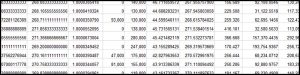
Coordinate Conversion Software
Below are two downloadable Excel spreadsheets you can use for common Wisconsin map projections — WISCRS (Wisconsin Coordinate Reference Systems), SPCS 83 (State Plane Coordinate Systems NAD 83) and WTM 83 (Wisconsin Transverse Mercator NAD 83).
The Excel spreadsheets are identical except for the format of input latitudes and longitudes. “Map Projection Functions Decimal Degrees Input.xlsx” accepts input latitudes and longitudes in decimal degrees. “Map Projection Functions DegMinSec Input.xlsx” accepts input latitudes and longitudes in degrees, minutes, and seconds.
The spreadsheets perform direct and inverse transformations between geodetic coordinates (latitudes and longitudes) and map projection coordinates (northings and eastings). They also compute convergence (mapping angle) and scale factor at each computed point. In addition, they will compute linear distortion if an ellipsoid height is provided.
A read-me file is also available below for more details on the spreadsheets.
NOTE: Earlier versions of these spreadsheets contained an incorrect value for the semi-minor axis. This error has been fixed and the January 2021 versions of the spreadsheets are correct in this regard.
Map-Projection-Functions-Decimal-Degrees-Input-Jan2021-Corrected
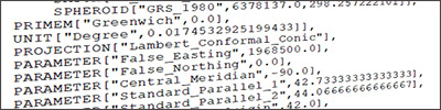
WIGGS Parameters
The following three documents were submitted to the National Geodetic Survey in September, 2020, in support of WSRS2022’s design submission for WIGGS (Wisconsin Grid Ground System). WIGGS supplants WISCRS as the state’s county-based low-distortion projection system for the modernized spatial reference system.
NOTE: WIGGS parameters are intended to be used with NATRF2022 — the new Terrestrial Reference Frame for North America being developed by the National Geodetic Survey — not with NAD 83 or earlier datums.
WIGGS Design Submission Form (PDF)
WIGGS Parameters (Excel Format)
WIGGS Zone Extents (Zipped Shapefile)
More details on the submission are provided in the following file:
Design Submittal (PDF)