University of Wisconsin–Madison
State Cartographer's Office
  • Jobs Expand Collapse
    • Open Positions
    • Student Internships
    • Archived Positions
    • Sign up for Job Alerts
    • National GIS Jobs Pages
  • Maps Expand Collapse
    • Aerial Photography
    • Lake and Lake Depth
    • Platbooks and Land Ownership
    • Topographic Maps
    • More >>
  • Data Expand Collapse
    • Aerial Imagery Data
    • Parcel Data
    • Wisconsin Elevation/LiDAR Data
    • GeoData@Wisconsin Data Portal
    • More >>
  • Community Expand Collapse
    • PLSS Work Group
    • WSRS2022: The Wisconsin Spatial Reference System 2022 Task Force
    • Local Govt Web Mapping Sites
    • Wisconsin Geospatial Events Calendar
    • WI Land Information Association
    • WI Land Information Officers Network
    • WI Society of Land Surveyors
    • More >>
  • News Expand Collapse
    • Wisconsin Geospatial News
    • Sign up for News Alerts
    • Searchable Online News Archives (2003 – Present)
    • Wisconsin Mapping Bulletin PDF Archives (1975 – 2003)
    • Wisconsin Geospatial Events Calendar
  • Learn Expand Collapse
    • Coordinate Reference Systems
    • Land Surveying and PLSS Topics
    • Wisconsin Bearing Trees
    • Magnetic Declination
    • Wisconsin Geography Trivia
    • More >>
  • Publications
  • Projects Expand Collapse
    • Heritage Oak Project
    • Major SCO Projects
  • SCO Expand Collapse
    • About the SCO
    • Contact Us
    • Staff
    • Publications
    • Major Projects
    • Alumni
    • Employment
    • UW-Madison Geography
  • Subscribe to SCO News Alerts
  • Donate
  • UW Geography

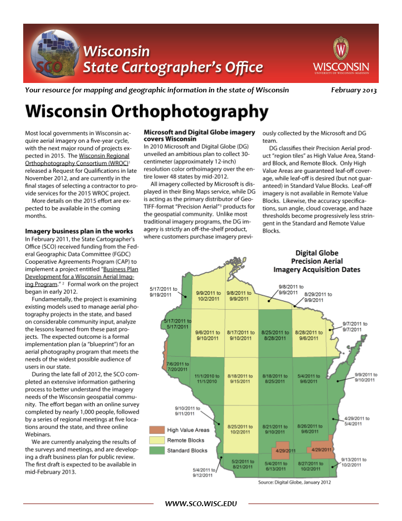
SCO Publications

Wisconsin Orthophotography (2013)

Published January 24, 2013
By Jim Lacy

This SCO infosheet discusses the current status of aerial imagery in the state of Wisconsin.

Download Publication (2 MB)

Tags: Aerial Photography, Orthophotography

Site footer content

University logo that links to main university website

SCO

  • About
  • Staff
  • SCO Publications
  • Major Projects
  • Employment

Quick Links

  • Platbooks and Land Ownership Maps
  • Aerial Photography
  • Lake and Lake Depth Maps
  • GeoData@Wisconsin
  • Wisconsin Elevation/LiDAR Data
  • Wisconsin Outline Maps

Contact Us

  • 384 Science Hall
    550 North Park Street
    Madison, WI 53706
  • Email: help@sco.wisc.edu
  • Phone: (608) 262-3065
    • twitter

Website feedback, questions or accessibility issues: help@sco.wisc.edu.

Learn more about accessibility at UW–Madison.

This site was built using the UW Theme | Privacy Notice | © 2025 Board of Regents of the University of Wisconsin System.