
Quick Links
Where to find the “best” lake map is a common question we receive each spring as fishing season approaches. While there is no single best source we can suggest, there are a number of options you can explore.
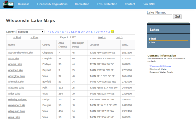
First, the most comprehensive source of bathymetric (depth contour) lake maps comes from the Wisconsin DNR. Visit the DNR Lakes page, and choose a county from the dropdown box near the top of the screen. Then, choose a lake from the list to view a scanned version of a paper lake map. Cartographically, the DNR maps are not very pleasing to the eye, and some maps date back to the 1940’s.
Three commercial outfits in Wisconsin also produce lake maps. If you would like a nicely polished cartographic product, Mapping Specialists in Madison produces a series of maps for nearly 200 popular Wisconsin lakes. Their maps use a nice shaded relief effect to enhance the appearance of bathymetric data, and include supplementary information such as stocking and plant life data, and notes from local fishing guides.
Fishing Hot Spots (FHS) in Rhinelander, a widely-known producer of lake maps throughout the U.S., lists over 100 Wisconsin lake maps on their website. In addition to their paper maps, FHS has partnered with several major GPS receiver manufacturers to make their products available on mapping-capable GPS receivers.
Sportsman’s Connection produces series of six regional guidebooks that cover Wisconsin. In addition to bathymetric maps, each guide contains a wealth of local fishing information and DNR stocking and survey data.
Wiscartography.com publishes a series of Wisconsin Lake Maps for select locations around the state. The company offers customization services to add a personal touch, such as the location of a home, cottage, or business.
Finally, also worth mentioning is the popular Delorme Atlas and Gazetteer of Wisconsin. Although the relatively small scale of the atlas (1:150,000) does not lend itself to showing a great amount of detail, the Delorme maps do show public boat landings across the state. For additional online boat landing information, visit the Wisconsin DNR’s Boat Access and Shore Fishing page.
Note: Commercial products mentioned on this page are not endorsed by the SCO or University of Wisconsin-Madison.