University of Wisconsin–Madison
State Cartographer's Office
University of Wisconsin-Madison
  • Jobs Expand Collapse
    • Open Positions
    • Student Internships
    • Archived Positions
    • Sign up for Job Alerts
    • National GIS Jobs Pages
  • Maps Expand Collapse
    • Aerial Photography
    • Lake and Lake Depth
    • Platbooks and Land Ownership
    • Topographic Maps
    • More >>
  • Data Expand Collapse
    • Aerial Imagery Data
    • Parcel Data
    • Elevation/LiDAR Data
    • GeoData@Wisconsin Data Portal
    • More >>
  • Community Expand Collapse
    • PLSS Work Group
    • WSRS2022: The Wisconsin Spatial Reference System 2022 Task Force
    • Local Govt Web Mapping Sites
    • Wisconsin Geospatial Events Calendar
    • WI Land Information Association
    • WI Land Information Officers Network
    • WI Society of Land Surveyors
    • More >>
  • News Expand Collapse
    • Wisconsin Geospatial News
    • Sign up for News Alerts
    • Searchable Online News Archives (2003 – Present)
    • Wisconsin Mapping Bulletin PDF Archives (1975 – 2003)
    • Wisconsin Geospatial Events Calendar
  • Learn Expand Collapse
    • Coordinate Reference Systems
    • Land Surveying and PLSS Topics
    • Wisconsin Bearing Trees
    • Magnetic Declination
    • Wisconsin Geography Trivia
    • More >>
  • Publications
  • Projects
  • SCO Expand Collapse
    • About the SCO
    • Contact Us
    • Staff
    • Publications
    • Major Projects
    • Alumni
    • Employment
    • UW-Madison Geography
  • Twitter
  • YouTube
  • LinkedIn
  • Donate
  • UW Geography

Wisconsin Geospatial News

2018 county datasets now available on GeoData@Wisconsin

By Jim Lacy
September 14, 2018

Through the Wisconsin Land Information Program (WLIP), geospatial data from Wisconsin counties is collected each spring in support of statewide data integration, benchmarking and archiving. In 2018, counties submitted parcel data – now available through the Parcel Data Initiative project page – as well as address points, buildings, hydrography, land use, roads, right-of-ways, parks, recreation, and trails. All data submitted by counties are now available for public download on the GeoData@Wisconsin geoportal.

GeoData@Wisconsin

GeoData@Wisconsin interface.

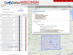
GeoData@Wisconsin is designed to provide single-source discovery and access to Wisconsin geospatial data, combining an intuitive map-based search interface with traditional text-based search capabilities. While originally created to serve university researchers and students, with restricted access to many datasets as a result of county data licensing requiremements, GeoData@Wisconsin now contains nearly 1,500 open datasets accessible to any user.

GeoData@Wisconsin was developed by the Robinson Map Library and the Wisconsin State Cartographer’s Office (SCO) at the University of Wisconsin-Madison. The Map Library and SCO maintain the geoportal using internal resources. Providing public access to geospatial data is an integral part of the mission of the Map Library and SCO, and aligns with the “Wisconsin Idea” linking the university to citizens’ lives throughout the state.

Wisconsin County Data

All 2018 data submitted by counties has been archived for long-term preservation at the Robinson Library. Publication datasets were created from the data by combining similar features into downloadable files. Including parcels, the 2018 data management process produced a total of 446 unique Wisconsin county datasets that are discoverable and available for public download on GeoData@Wisconsin.

All downloadable datasets are documented with complete metadata. Student assistants in the Library worked for five months (April-September, 2018) to write metadata for each dataset in both FGDC and ISO formats. Metadata is directly viewable in GeoData@Wisconsin so that users can find out more about the data before they download it.

More Data Now Public

When it was first released in 2014, data linked from GeoData@Wisconsin was primarily restricted to higher education users in the state.  Fast forward to today, and the geoportal now contains 1,486 public datasets that may be downloaded for free by any user.  Our next project will be opening up much of the restricted data (1,130 additional datasets) for public download.  Permission to do this was granted by most counties last spring.

To browse Wisconsin geospatial data, visit geodata.wisc.edu.

Tags: Geodata, Geospatial Data, Metadata, Robinson Map Library

Recent News

  • Identifying Wisconsin’s Cartographic Phantoms
    March 23, 2023
  • Wood County Seeks Proposals for new County Highway Transportation Project Plat
    March 17, 2023
  • Elza receives WLIA Emerging Leader Award
    March 4, 2023
More News More

Also See

  • 2017 county datasets now available on GeoData@Wisconsin February 19, 2018
  • SAGIC Selects GeoData@Wisconsin for Cross-Agency Data Access October 9, 2020
  • GeoData@WI and WisconsinView overflowing with new aerial imagery June 25, 2021
  • New report highlights current status of WLIP November 29, 2012
  • V4 statewide parcel web app and data download now available July 31, 2018

News Alerts

Sign up to receive our weekly e-mail news updates

Site footer content

University logo that links to main university website

SCO

  • About
  • Staff
  • SCO Publications
  • Major Projects
  • Employment

Quick Links

  • Platbooks and Land Ownership Maps
  • Aerial Photography
  • Lake and Lake Depth Maps
  • GeoData@Wisconsin
  • Elevation/LiDAR Data
  • Wisconsin Outline Maps

Contact Us

  • 384 Science Hall
    550 North Park Street
    Madison, WI 53706
  • Email: help@sco.wisc.edu
  • Phone: (608) 262-3065
    • twitter
    • youtube
    • linkedin

Feedback, questions or accessibility issues: help@sco.wisc.edu.

Privacy Notice | © 2023 Board of Regents of the University of Wisconsin System.