Geospatial professionals working in Wisconsin have long lamented the lack of an authoritative source of accurate administrative boundaries for the state. The Wisconsin Legislative Technology Services Bureau (LTSB), the technical services branch of the Wisconsin Legislature, recently began a project aimed at improving the flow of boundary data between local governments and the U.S. Census Bureau.
While Minor Civil Divisions (MCDs, a.k.a., cities/villages/towns) is a dataset freely available from the Census Bureau, it is often considered less than ideal for applications requiring a high degree of accuracy and/or currency. Because of this, multiple state agencies in Wisconsin maintain their own MCD layers, derived from a hybrid of Census and local data. Go looking for one of those hybrid MCD layers, and you will quickly learn there is no clear “best” source for administrative boundaries in Wisconsin.
C-BAS aims to improve boundaries
The Census Bureau has for many years operated their Boundary and Annexation Survey (BAS) program. In this program, local government officials can provide updated boundary information directly to the Census Bureau using a variety of methods. Unfortunately, participation in the voluntary BAS program has been limited, not just in Wisconsin, but across the nation as well.
In response to the reality that many city, village, and town officials often do not have the time, resources, or technical knowledge required to report boundary changes directly to the federal government, the Census Bureau developed the “Consolidated” Boundary and Annexation Survey, or C-BAS. Under the C-BAS program, county governments can obtain permission from cities, villages, and towns to act on their behalf, and submit updates directly to the Census.
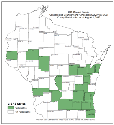
Census representatives have been educating Wisconsin counties on the benefits and details of C-BAS in over the last six months. As of August 1, 21 counties have officially signed up for the program. (See map)
LTSB steps in to help
While C-BAS is a great step towards improving the flow of data between local governments and the Census, most County government resources are already stretched thin as well. Reconciling county-maintained boundary data with Census MCDs may not always rise far on the list of priorities due to limited staff, budgets, and time.
Enter LTSB. Among their many duties associated with serving the Wisconsin Legislature, LTSB is responsible for the logistics of the statewide legislative redistricting process. That process is required to use data from the U.S. Census. Even though LTSB staffers are very much aware that many local governments maintain accurate municipal boundaries, they are currently prohibited by law from using those datasets.
Based on their experience working with many of the approximately 1,900 municipalities in the state for redistricting, LTSB recently kicked-off a process to help local governments send updated boundary data to the Census Bureau, while at the same time creating authoritative statewide datasets needed in state government.
Boundary Annexation Survey Tool
To ease the process of submitting data to the Census under the C-BAS program, LTSB is developing an ArcGIS-based tool to help spatially correct Census boundary data and report annexations using locally-produced data. In short, the tool will allow counties participating in C-BAS to quickly compare County and Census datasets, and generate files in the Census-required format for electronic submittal.
In addition to prepping data for the Census, local data run through the LSTB Boundary Annexation Survey Tool will be saved to the Wisconsin Shape Editor for Local Redistricting (WISE-LR) system. This in turn can be used to generate much-improved statewide layers such MCDs and wards.
The LTSB tool is expected to be freely available as an ArcGIS project file in September from the LTSB Web site. The tool will also be made available in other formats by January 2013, including a geoprocessing tool that will be published to the web via ArcGIS Server.
High expectations for the future
While the success of the LTSB effort to support C-BAS and improved boundaries will not be known until next summer, I’m very encouraged by their work thus far. LTSB has a very strong business need for improved Census boundary data, and therefore a clear stake in improving the status quo. They have a staff willing to help counties through the process, and have stepped-up to develop and maintain a tool that will ease the burden on local governments.
There are many potential beneficiaries of the LTSB project: the Wisconsin Legislature will have more accurate boundaries on which to base future redistricting efforts; local governments will save significant time and energy; the Government Accountability Board (GAB) will have improved data for their Statewide Voter Registration System; counties will have a higher degree of confidence that locally-produced data will be used by state agencies for making decisions, and the U.S. Census Bureau will have access to much better boundary data for their own work.
And if all goes as hoped, GIS professionals will finally have an authoritative, accurate spatial dataset representing MCDs in Wisconsin.
Ultimately, of course, citizens are the winners in any project that improves G2G (government to government) data sharing. If LTSB is effective in partnering with counties and the U.S. Census Bureau, I think the project could serve as a great model for future coordination efforts between all levels of government in Wisconsin.

