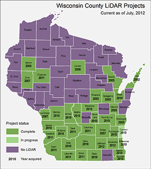
Over the last few years the SCO has published several maps and articles on LiDAR data in Wisconsin. Other organizations, including the Wisconsin DNR, the US Geological Survey, and the Wisconsin Geographic Information Coordination Council (WIGICC), have also been collecting and distributing information about LiDAR data. In an effort to bring together these various sources of LiDAR information, we created a map showing the status of LiDAR projects in the state.
Although some counties have been collecting LiDAR data since the mid-2000s, the biggest impetus for acquiring this data came from Department of Commerce CDBG (Community Development Block Grant) funds starting in 2010. The grant program is significant in that it directly facilitiated the collection of high-resolution elevation data for the southern part of Wisconsin. Much of this data has now been acquired or is in the final stages of processing.
A few notes about the map:
(1) It shows only LiDAR projects. Photo-derived elevation projects are not included.
(2) It shows most-current projects only. Multiple projects are not shown in those cases where a county has more than one.
(3) It shows county projects only. It does not show projects for individual cities, coastal areas, river corridors, etc.
(4) It does not show counties with planned projects except for the CDBG-funded counties that have funding in place.
Missing counties on the map indicate that we are not aware of any existing LiDAR project for that county, although such a project may be planned for.
As noted, this map combines information from previous maps and surveys. The assistance of the following organizations is gratefully acknowledged: Wisconsin DNR, US Geological Survey, Ayres Associates, LION (Land Information Officers Network), WLIA (Wisconsin Land Information Association), WIGICC (Wisconsin Geographic Information Coordination Council), and LIOs from individual counties.
Please direct inquiries or comments to Howard Veregin at (608) 262-6852.
Note (9/3/2014): The original map created for this article was an interactive Web map. In September 2014 this was replaced with a static map as much of the information in the original Web map is now out of date. For a recent LiDAR map see this Mapping Bulletin article.

