
Note: This is a condensed version of a five-part blog post I recently posted on Oddsconsin. The Oddsconsin posts examine the history of the state’s boundaries with Illinois, Michigan and Minnesota, focusing on early surveyors, the role of the federal government, legal battles and other disputes over boundary location. This post focuses on where the boundary is and why it is there, as well as challenges that we still face in accurately mapping it.
Introduction
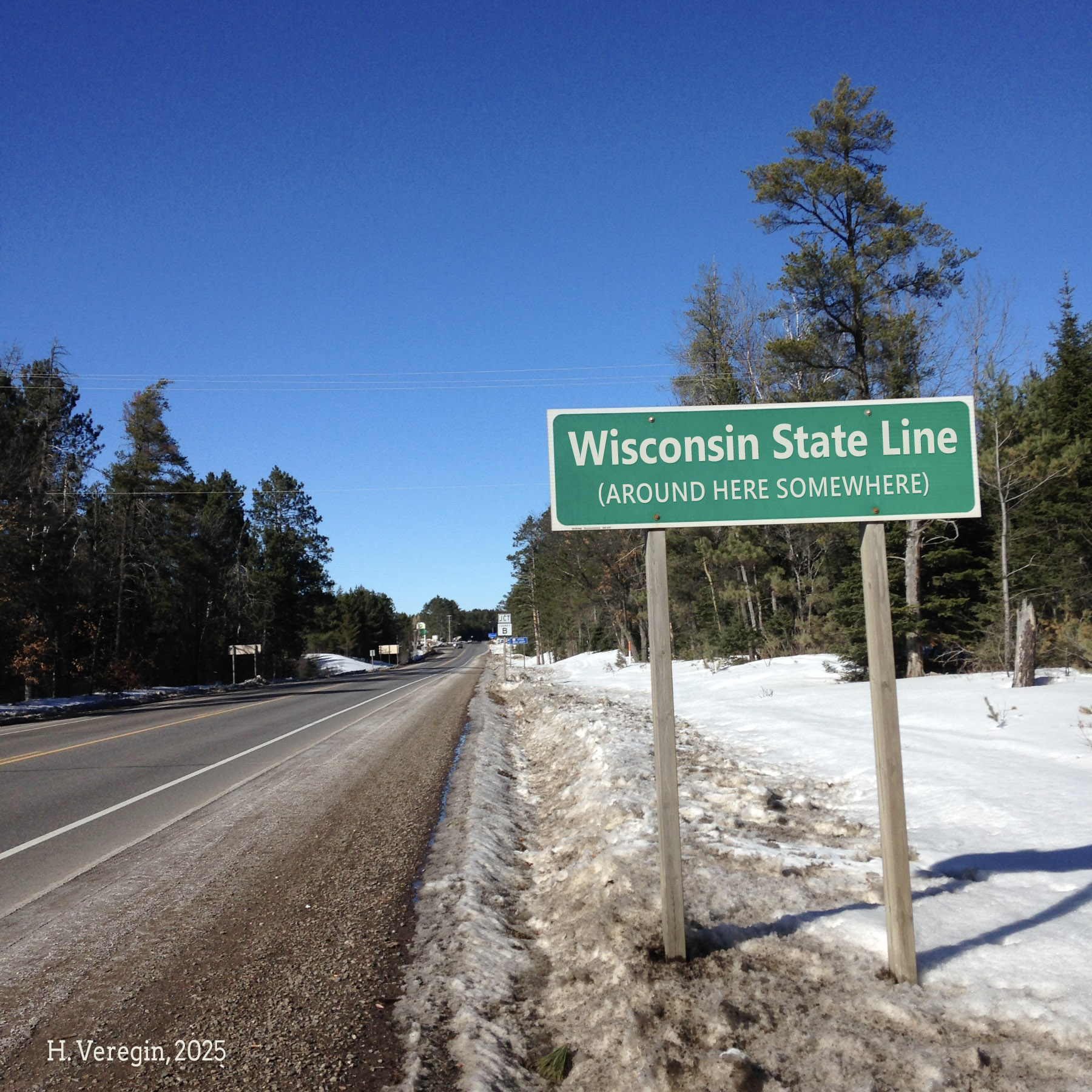
Most maps of the Wisconsin boundary are not very accurate. They are often generalized for use at smaller scales, do not follow exact locations of known boundary monuments and tend to disagree with each other. To complicate matters, the locations of some parts of Wisconsin’s boundaries are a bit ambiguous, others are in open water making physical monumentation difficult, and others are based on surveys done as early as the 1830s when surveying technology was less sophisticated than it is today.
The legal boundaries of the state are described in Article II of the Wisconsin Constitution. [1] Wisconsin’s boundaries were the subject of great debate at the time the constitution was being drafted in the 1840s. The boundary description we find in the constitution today is based on the 1846 Enabling Act that Congress passed to pave the way for statehood.
That 1846 boundary is in turn based on – but not identical to – the boundary described in the 1836 law that carved Wisconsin Territory out of Michigan Territory. The boundary in the 1846 Enabling Act is also different from the boundary in the version of the state’s constitution that was approved by Wisconsin voters in March of 1848. But the boundary in the 1848 constitution is not the same as the boundary in the constitution ratified by Congress, which adopted the boundary definition we see in the constitution today.
Chapter 2 of State Statutes also gives the boundaries of the counties, including those that border our neighboring states. However, there is no additional information provided on the state boundary portions of those counties. The statutes simply refer to “the southern boundary line of this state” or “the boundary line between the states of Michigan and Wisconsin.” [2]
If this all sounds confusing, that’s because it is.
The differences between the Wisconsin Constitution and the 1846 Enabling Act relate primarily to the Michigan boundary. The differences between the current Wisconsin Constitution and the version of the constitution approved by voters in 1848 relate primarily to the boundary with Minnesota. But first, we’ll focus on the boundary with Illinois, which is probably the most straightforward portion of Wisconsin’s boundary. We won’t look at Iowa, simply in the interests of space.
Illinois
In the case of Illinois, the boundary description in the state’s constitution does not actually reflect the location of the state boundary as it exists today. The Wisconsin Constitution defers to the law that created the state of Illinois in 1818. Accordingly, the boundary is defined as “the line of forty-two degrees and thirty minutes of north latitude.”
A line of latitude (or a parallel) is an imaginary line on the earth’s surface that follows a path of constant bearing with respect to true north. It is in that sense a straight line, although it naturally follows a curved trajectory since the earth is ellipsoidal in shape.
The first and most obvious problem with the Wisconsin-Illinois boundary is that it is not a straight line. [3] It contains numerous bends and wobbles, the result of surveying technology of the nineteenth century. When surveyors marked the boundary in 1833, they believed they were at 42 degrees, 30 minutes north, but their locations were not precise.
Another problem is that the boundary is not at 42 degrees, 30 minutes north. The reason is that latitude and longitude are not fixed, due to “shift and drift.” Drift is due to plate tectonics, the rotation and movement of large, rigid plates on the earth’s crust. Everything on the plate is rotating, including the boundary line with Illinois, which has shifted about 17 feet since it was defined in 1818.
Shift occurs because, as more precise measurements of the earth are acquired, scientists tinker with the mathematical model used to represent the generalized shape of the earth. Whenever a new model is adopted, the latitude and longitude of every point changes.
When the Wisconsin-Illinois boundary was delineated in 1833, surveyors were trying to follow a line of latitude that was believed to be farther south than it is today. The line has moved north. If the boundary were surveyed accurately today, Illinois would gain territory at Wisconsin’s expense. (However, due to the bends and wobbles in the boundary, some parts of it are actually too far north.)
But don’t expect the boundary to be changed anytime soon. Despite what the state’s constitution says, the boundary is where the physical monuments set in 1833 say it is. The courts have generally upheld the principle that effective administration and control of an area, over time, is the key to establishing ownership.
Minnesota
Wisconsin’s boundary with Minnesota is more complex, since it includes both straight-line and river segments. The boundary starts in Lake Superior, travels a few miles up the St. Louis River, turns due south in a straight line to the St. Croix River, follows the St. Croix to the Mississippi River, and then follows the Mississippi south. It merges with the Iowa boundary, which ends at the Illinois line.
The Wisconsin Constitution states that the boundary in the St. Louis River runs up the main channel “to the first rapids in the same, above the Indian village, according to Nicollet’s map.”
The reference to Nicollet’s map seems a bit unusual. First off, who was Nicollet? And second, what map is the constitution referring to?
Historians agree that the constitution is referring to Joseph Nicollet (1786-1843), a French astronomer, explorer and cartographer who surveyed the upper Mississippi region in the 1830s. The map referenced in the constitution is his 1843 map titled, Hydrographical Basin of the Upper Mississippi River. [4]
The map’s depiction of northwest Wisconsin is based on observations made by Nicollet during his 1836-37 expedition. Clearly visible, on the south bank of the St. Louis River in present-day Douglas County, is the Indian village referenced in the constitution.
A convenient spot, perhaps, but a bit imprecise as far as marking the location where the boundary takes a 90-degree turn. Perhaps that’s why the straight-line section of the Wisconsin-Minnesota boundary, which runs from the rapids on the St. Louis River “due south to the main branch of the river St. Croix” is not where it is supposed to be.
This straight-line section of the boundary is aligned to the state’s Public Land Survey System (PLSS), or at least, it’s supposed to be. The PLSS’s framework of townships was established in a mammoth surveying effort led by the General Land Office, in which survey crews placed wooden posts (or sometimes mounds of dirt) at the locations they determined to be township corners. It took over thirty years – from the 1830s to the 1860s – to complete the work in Wisconsin.
In northwest Wisconsin, the dividing line between townships in Ranges 15 and 16 was intended to be the location of the Wisconsin-Minnesota boundary. [5] However, the boundary line runs through the interior of the townships in Range 15, shortchanging the Towns of Superior, Summit and Dairyland in Douglas County and the Town of Blaine in Burnett County.
This problem was identified early on but never corrected. In 1929, Wisconsin allocated funds to have the line reestablished by a Wisconsin-Minnesota survey team, but Minnesota took no action. [5]
But why was this location selected as the northwest corner of Wisconsin in the first place? To answer that, we need to go back to the Northwest Ordinance of 1787, which created the Northwest Territory from lands ceded by eastern states. Eventually, the states of Ohio, Indiana, Illinois, Michigan, Wisconsin and a portion of Minnesota would be carved out of the Northwest Territory. [6]
The western boundary of the Northwest Territory was the Mississippi River up to its source in what is now the state of Minnesota, then in a direct line north to the international border with Britain (now Canada). This became the western boundary of Wisconsin Territory in the 1830s, after Michigan was admitted as a state. But that changed in the Enabling Act of 1846, which Congress passed to pave the way for Wisconsin statehood. The Enabling Act is where we first see Wisconsin’s modern boundary with Minnesota.
In the two years between the Enabling Act (1846) and statehood (1848), this portion of the Wisconsin-Minnesota boundary was redrawn several times. The debate was heated and emotional, in large part because it affected the balance of power in the US Senate between free states and slave states. Since the Missouri Compromise of 1820 prohibited slavery in new northern states, many southern politicians wanted the Wisconsin boundary to be as far west as possible to ensure that no additional free states could be created out of the old Northwest Territory. In contrast to these so-called “fifth-staters,” a coalition of northern interests known as the “sixth-staters” wanted Wisconsin to be much smaller, so that an additional free sixth state to the west of Wisconsin could be created.
At the first Wisconsin Constitutional Convention in 1847, the sixth-staters were able to get one of their boundary proposals into the constitution. This boundary ran north to the St. Louis River from present-day Pepin County, many miles to the east of the present boundary. However, this version of the constitution was rejected by Wisconsin voters. At the second Constitutional Convention in 1848, the political climate had shifted, and a new boundary was inserted into the state’s constitution that extended to the confluence of the Mississippi and Rum Rivers, some ten miles northwest of Minneapolis.
However, the Rum River boundary was never seriously considered by Congress, since they had already made a boundary offer to Wisconsin in the 1846 Enabling Act. The state’s constitution was redrafted using the language of the Enabling Act to produce the boundary we see today. The two years of debate, in which Wisconsin’s western boundary bounced back and forth across the St. Croix River, was all for nothing. [7]
The important point here is the authority of the federal government to establish the boundaries of new states. This is a topic that will arise again in relation to Wisconsin’s boundary with Michigan.
There’s one more section of the Wisconsin-Minnesota boundary we haven’t discussed – the portion that goes “down the center of the main channel” of the Mississippi River. The problem here is that no one really knows where the center of the main channel was when Wisconsin became a state. Detailed maps from 1848 don’t exist. Trying to reconstruct the old channel is difficult today, because the river has been heavily impacted by dredging and reshaping in the construction of dams, locks and other engineering projects. The boundary lies somewhere within the shorelines of the Mississippi River, but its exact location is a matter of debate. [8]
Michigan
Wisconsin’s boundary with Michigan’s Upper Peninsula has a contentious history. The constitution describes the boundary as running from the
mouth of the Menominee river; thence up the channel of the said river to the Brule river; thence up said last-mentioned river to Lake Brule; thence along the southern shore of Lake Brule in a direct line to the center of the channel between Middle and South Islands, in the Lake of the Desert; thence in a direct line to the head waters of the Montreal river, as marked upon the survey made by Captain Cramm; thence down the main channel of the Montreal river to the middle of Lake Superior.
Who was Captain Cramm and what did he do to earn a mention in the state’s founding document (along with Joseph Nicollet)?
Captain Thomas Cramm (usually spelled Cram, 1804-1883) was an engineer in the U.S. Army Corps of Topographical Engineers. Cram was charged with surveying the boundary between Wisconsin and Michigan following the separation of Wisconsin Territory from Michigan Territory in 1836 and the creation of the state of Michigan in 1837.
The boundary was described in 1836 as following the
mouth of the Menomonie [Note: now spelled Menominee] river; thence through the middle of the main channel of said river to the Brule river, to that head of said river nearest to the Lake of the Desert; thence in a direct line to the middle of said lake; thence through the middle of the main channel of the Montreal river, to its mouth.
This description is a bit different from the one in the constitution. Both reference Lake of the Desert, but the 1836 description is based on the incorrect belief that Lake of the Desert drained westward through the Montreal River into Lake Superior. [9]
During his 1840 expedition, Captain Cram found it was impossible to follow the 1836 description. First, he did not find a lake called Lake of the Desert, so he decided that Lake of the Desert was in fact Lac Vieux Desert. He also discovered that the Montreal River did not drain this lake, but was an eight-day journey overland to the west. He recommended using a point in Lac Vieux Desert as a turning point on a straight-line boundary connected to the Montreal River in the west. [10]
Cram’s follow-up expedition of 1841 identified the eastern branch of the Montreal River as the main channel. He made an astronomical observation at the junction of what were then known as the Balsam and Pine Rivers, which he considered the headwaters of the Montreal River.
Cram’s information was used by Congress to modify the 1836 Michigan-Wisconsin boundary description in the 1846 Enabling Act. Cram’s point on the Montreal River was specifically included in the boundary description as a precise, surveyed location. [5]
A year before statehood, in 1847, the Michigan-Wisconsin boundary was surveyed and monuments were set at half-mile intervals. These were simply wooden posts, but they defined the boundary unambiguously on the ground. The survey was conducted by the Surveyor General’s Office and certified that same year.
The case seemed to be closed, but then Michigan initiated a lawsuit that went all the way to the US Supreme Court. The dispute went back to Michigan’s 1850 constitution (Michigan has revised its constitution several times), which defined the boundary as running to the headwaters of the Montreal River without mentioning Cram’s point. Michigan’s 1908 constitution went a step further, stating that the line went through the main channel of the west branch of the Montreal River to its headwaters in Island Lake, ten miles southwest of Cram’s point. [11]
In 1923, Michigan sued Wisconsin to redetermine the boundary based on these claims. The result was a wedge of disputed territory about 400 square miles in extent within Iron and Vilas Counties. [10]
The Supreme Court’s decision in 1926 was almost anticlimactic. It rejected Michigan’s claims and upheld the boundary as originally surveyed and monumented, pointing out that Wisconsin had exercised effective administration of the disputed area since it became a state in 1848. [5]
The court’s ruling also noted Michigan’s long-standing acquiescence of the border, even though the mistaken assumption that the Montreal River connected to Lake of the Desert “was discovered as early as 1841, of which discovery Michigan, long prior to the admission of Wisconsin, had knowledge.” [12]
The lawsuit was dismissed.
The ruling also addressed some other parts of the Wisconsin-Michigan boundary, including the islands in the Menominee River, in Green Bay and in Lake Michigan north of Door County. The language of the ruling caused confusion about these islands, and so a second lawsuit was launched by Michigan in the 1930s. [13]
Between 1928 and 1929, the boundary was resurveyed by a Michigan-Wisconsin Joint Boundary Commission. Concrete monuments topped with small metal tablets replaced the original wood posts. These monuments still exist today and are maintained by Wisconsin and Michigan county surveyors. [14]
The mistaken assumption about the course of the Montreal River – the main source of the dispute – isn’t easily erased. In the Wisconsin Constitution, Cram’s point is defined as being at the headwaters of the Montreal River. This may have been the belief at the time of Cram’s expedition, but today the source of the river is known to be Pine Lake, several miles to the south of Cram’s point. [15] This is yet another example of how geographical misinformation becomes a legal fact that time – and lawsuits – cannot undo.
What’s Next?
In this article I’ve tried to highlight the contentious nature of our boundary with our neighboring states, its imprecision and even inaccuracies, and the difficulty of reconciling our official boundary – as described in the constitution – with modern geographical reality.
The modern boundary – despite these warts – is defined de facto by the existence of survey markers that the neighboring states agree upon. This includes the boundary with Illinois, the straight-line segments of the boundary with Michigan and Minnesota, and even several open water areas, including the St. Louis River estuary. Certain water boundaries, including the Menominee River, Green Bay and the waters north of Door County have been delineated according to rulings of the US Supreme Court. In other cases, such as the Mississippi River, there is some ambiguity, but a resolution could probably be reached if the states worked together.
Getting back to the subject of maps – which is how this article started – action is necessary. A truly accurate map of the state’s boundary needs to start from best-available PLSS corner data, coordinates from boundary monuments, and information from those state and federal agencies that established boundary locations in rivers and open water (to the degree these exist). Since some portions of the boundary are ambiguous, the data model used for the boundary map needs to be flexible so that more accurate boundary data can be added as it becomes available.
This goal is not unachievable. Our state deserves an authoritative depiction of its boundaries.
Thoughts? Comments? Suggestions? Send me an email.
Sources and Notes
[1] Wisconsin Constitution. https://docs.legis.wisconsin.gov/constitution/wi_unannotated
[2] Wisconsin State Statutes, Chapter 2. https://docs.legis.wisconsin.gov/statutes/statutes/2
[3] H. Veregin, Is the Wisconsin-Illinois Boundary a Straight Line? Wisconsin State Cartographer’s Office. https://www.sco.wisc.edu/2023/12/21/is-the-wisconsin-illinois-boundary-a-straight-line
[4] Library of Congress, Hydrographical basin of the upper Mississippi River from astronomical and barometrical observations, surveys, and information. https://www.loc.gov/item/78692260
[5] Wisconsin Historical Records Survey, Origin and Legislative History of County Boundaries in Wisconsin. Madison, WI, 1942.
[6] National Archives, Northwest Ordinance (1787). https://www.archives.gov/milestone-documents/northwest-ordinance
[7] This (abbreviated) history is based on the following sources: a) Wisconsin Historical Records Survey, Origin and Legislative History of County Boundaries in Wisconsin. Madison, WI, 1942. b) Franklin K. van Zandt, Boundaries of the United States and the Several States. Geological Survey Professional Paper 909, Washington, DC, 1976. c) William E. Lass, Minnesota’s Separation from Wisconsin, Minnesota History, Winter 1987, pp. 309-320. d) Colin Mustful, 2021, The Original Border Battle. https://www.colinmustful.com/borderbattle/
[8] Bryan Meyer, The “Lost” Wisconsin-Minnesota State Line. https://umgeocon.org/the-lost-wisconsin-minnesota-state-line/
[9] Franklin K. van Zandt, Boundaries of the United States and the Several States. Geological Survey Professional Paper 909, Washington, DC, 1976.
[10] Lawrence Martin, The Michigan-Wisconsin Boundary Case in the Supreme Court of the United States, 1923–26, Annals of the Association of American Geographers, Vol. 20, No. 3, 1930, pp. 105-163.
[11] 1908 Michigan Constitution. https://www.legislature.mi.gov/documents/historical/miconstitution1908.htm
[12] Michigan v. Wisconsin, 270 U.S. 295 (1926). https://supreme.justia.com/cases/federal/us/270/295/
[13] Lawrence Martin, The Second Wisconsin-Michigan Boundary Case in the Supreme Court of the United States, 1932–1936, Annals of the Association of American Geographers, Vol. 28, No. 2, 1938, pp. 77-126.
[14] For an example, see Mile Marker 33, established by William A. Burt, U.S. Deputy Surveyor, in 1847. The original monument was replaced with a concrete post with a brass template in 1928. https://maps.vilascountywi.gov/webdocs/corners/4308142708.pdf
[15] Wisconsin Department of Natural Resources, Surface Water Viewer. https://apps.dnr.wi.gov/water/waterDetail.aspx?WBIC=2940300
Oddsconsin Links
For further reading…