
A reader recently asked, “Is the Wisconsin-Illinois boundary a straight line? Based on the Wisconsin and Illinois Constitutions, it seems like it should be a straight line at 42 degrees, 30 minutes north latitude. But if you look closely at the boundary on maps, it bends a bit here and there. Is this an artifact of old surveying methods? Is it an artifact of flat maps and a sphere’s surface? What’s the explanation?”
Why Isn’t the Boundary Straight?
Article II of the Wisconsin Constitution accepts the state boundaries prescribed by Congress in 1846. The boundary begins “at the northeast corner of the state of Illinois — that is to say, at a point in the center of Lake Michigan where the line of forty-two degrees and thirty minutes of north latitude crosses the same.” From there. the boundary heads north. On the western edge of Wisconsin, the boundary traces south down the main channel of the Mississippi River until it reaches “the northwest corner of the state of Illinois; thence due east with the northern boundary of the state of Illinois to the place of beginning.”
The Illinois Constitution of 1818 (the first of the state’s four constitutions) tells the same story. The northern boundary of the state starts at a point in the center of Lake Michigan at forty-two degrees and thirty minutes north latitude, and then proceeds west to the middle of the Mississippi River.
Based on these descriptions, the Wisconsin-Illinois boundary should be a straight line. But it is not a straight line. It has many small bends in it, and it weaves in and out of alignment with the line of latitude at 42 degrees 30 minutes north. While the intent was to produce a boundary that was reasonably straight and aligned to latitude, what prevented this was surveying technology of the nineteenth century.
In this article I talk about Wisconsin county boundaries and observe that most of them are based on what is known as the PLSS — or Public Land Survey System — which created the regular blocks of one-square-mile sections and larger townships that still define patterns of land ownership in the state today.
As surveyors carved out chunks of land to survey, they laid down physical monuments at each half-mile increment along hundreds of section lines that criss-cross the state. They did an amazing job, but of course they worked with steel tape, metal chains, and magnetic compasses (no GPS!). The locations were not precise. When you look at the Illinois boundary today you are seeing what happens when you connect one of these monuments to the next one in the sequence. You can think of the chain of PLSS monuments as a “realization” of the idealized boundary line.
An Example
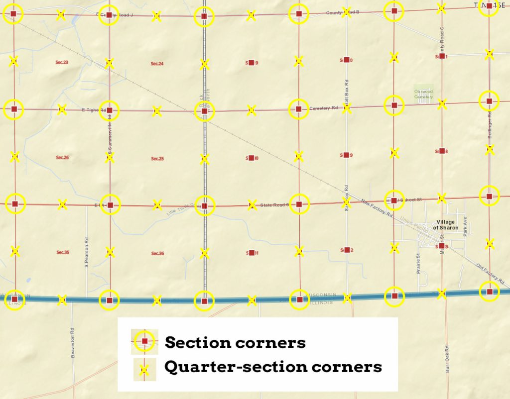
The map below (an annotated screenshot from the SCO’s Survey Control Finder online app) shows a portion of the state boundary near the Village of Sharon, Wisconsin. The border between Rock and Walworth Counties runs north-south roughly through the center of the map. The red lines are section lines connecting section corners and quarter-section corners, both of which have been highlighted on the map with different symbols. Section corners occur where an east-west and a north-south section line intersect. These corners are approximately one mile apart. Quarter-section corners occur mid-way (i.e., a half-mile) from the section corners along section lines. The blue line is the state boundary with Illinois. The blue coloring obscures the fact that this boundary line is made up of a series of section lines.
You can see how the section and quarter-section corners along the state boundary don’t follow an exact east-west course. Therefore the blue state line is also warped.
When Illinois became a state in 1818, the area around Sharon had not yet been surveyed. According to the original General Land Office survey notes the section lines along the Wisconsin-Illinois boundary in this area were surveyed in January, 1833. In effect, the state boundary in this area before that time was still “theoretical” or “unenforceable.” The PLSS survey made it real. The US government established the physical basis of land subdivision through PLSS so that land could be conveyed — some to military veterans, but most to the general public, both for a fee and later through the Homestead Act, for free after certain conditions were met.
This page explains that the “starting point of the public land survey in Wisconsin is located on the Wisconsin-Illinois border about 10 miles east of the Mississippi. This point, known as the initial point, marks the intersection of the baseline, which is also the southern state boundary, and the principal meridian, which is a line that runs due north from the initial point.”
That is, the Wisconsin PLSS baseline and the state boundary are one in the same. Another way of saying this is that the legal descriptions of property defined via PLSS are now are what define the boundary.
The Baseline Survey
A surveyor named Lucius Lyon conducted the survey of the entire baseline in 1833. The image below is the title page from his report.
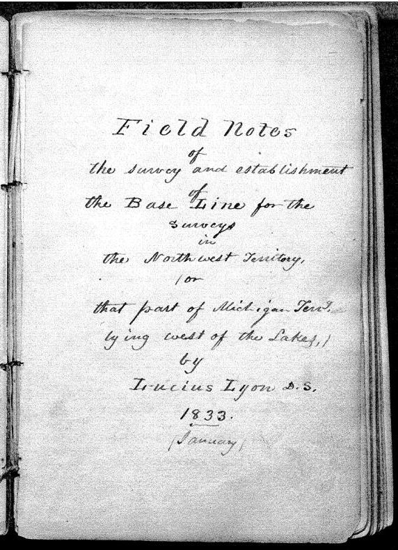
Note that at this time, in 1833, Wisconsin was administratively part of Michigan Territory.
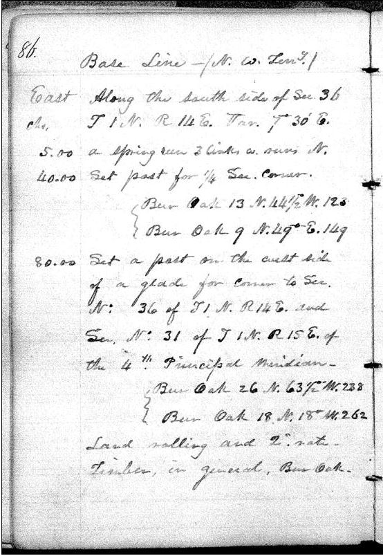
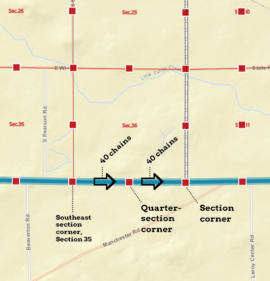
Below is the original survey note page for the section in the southeast corner of Rock County (section 36, Township 1 North, Range 14 East of the principal meridian). This explains that as Lyon and his crew moved east along the section line, they set a quarter-section monument (a post) 40 chains (1/2 mile) from the eastern edge of the previous section (section 35), and then set a section corner monument (another post) at 80 chains (1 mile).
The annotated screenshot below from Survey Control Finder shows this visually.
At this time, in 1833, therefore, the boundary between Illinois and Wisconsin Territory was a series of wooden posts (and in some areas, earthen mounds).
State Boundaries and Property Boundaries
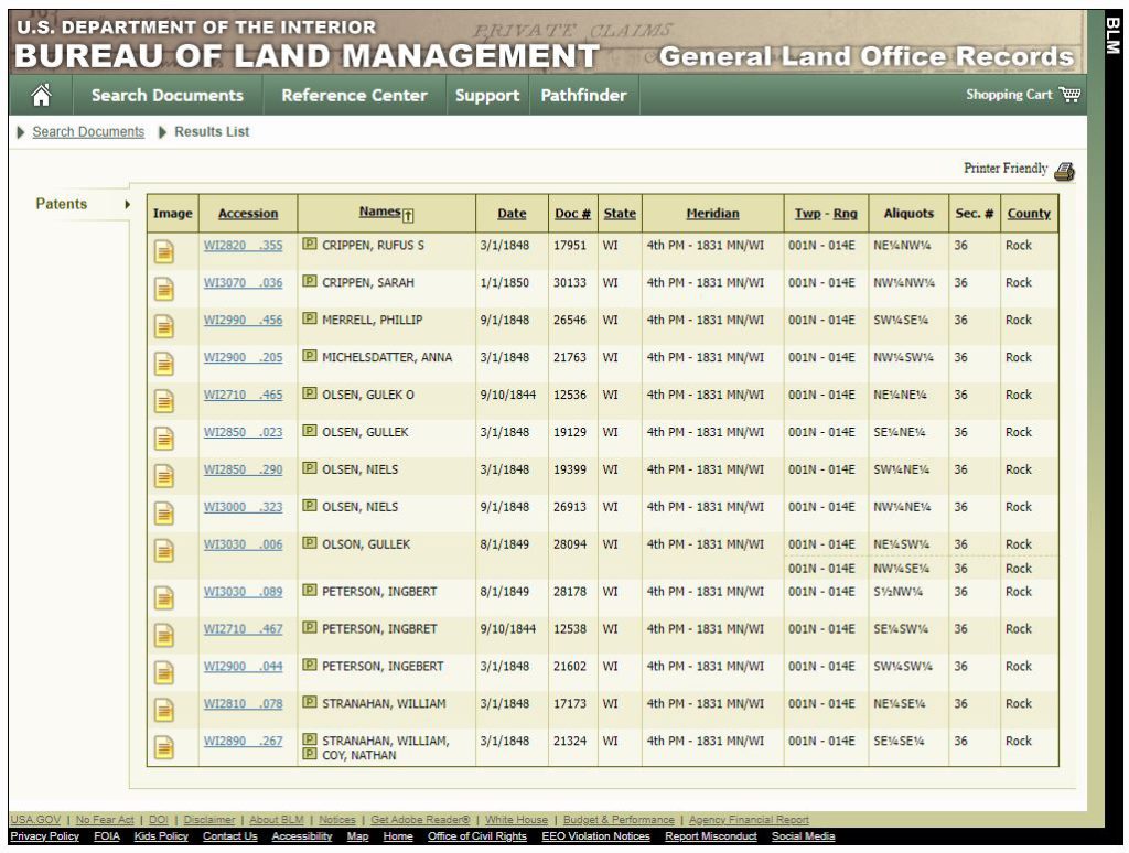
This Bureau of Land Management site lets you see the patents that were filed for PLSS land across the country. For section 36, Township 1 North, Range 14 East (the section shown in the map above), the first patents were from 1844. Other patents were filed in the 1840s and 1850s, most of them while Wisconsin was not yet a state. If you add up all of the “aliquots” listed here, it accounts for every piece of section 36.
In order for patents to be filed and land conveyed to the new owner, and “interior survey” was required. Lyon’s 1833 survey only covered the baseline, what is now the Wisconsin-Illinois boundary. The sections to the north of the baseline were delineated at a later date. In the case of section 36, Township 1 North, Range 14 East, this interior survey was conducted in 1837, shortly after the formation of Wisconsin Territory in 1836.
The sequence of events leading to the final physical delineation of the Wisconsin-Illinois boundary was therefore: 1) “Theoretical” definition of the boundary in Illinois state constitution; 2) Baseline survey in 1833; 3) Interior survey in 1837; 4) Filing of land patents starting in the 1840s.
In this part of the state, then, land ownership and the state boundary exist hand-in-hand. This is not necessarily true everywhere; PLSS is notoriously full of exceptions and counter-examples. But along the Wisconsin-Illinois boundary, this is the case.
And that, in a nutshell, is why the Wisconsin-Illinois boundary is not a straight line.