
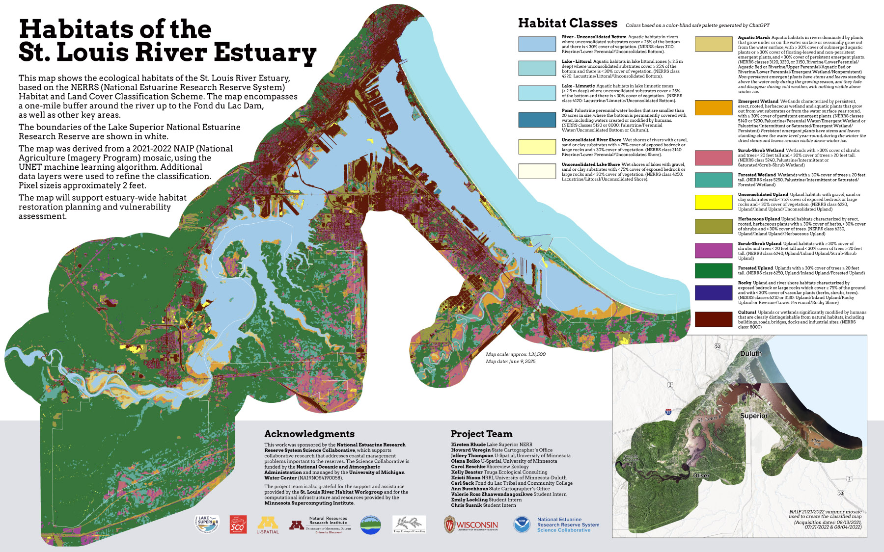
A team of researchers from Wisconsin and Minnesota has completed work on a project to map the habitats of the St. Louis River Estuary. The St. Louis River separates Wisconsin and Minnesota in the Duluth-Superior area. The map extends a mile or more beyond the boundaries of the river, from Lake Superior up to the Fond du Lac Dam.
Background and Collaborators
As noted in an earlier post the project responds directly to the needs of the St. Louis River Habitat Workgroup, who are in the process of updating the 2002 St. Louis River Habitat Plan. The map will be used to identify and prioritize areas for future restoration and conservation.
The project was funded by a grant from NOAA’s National Estuarine Research Reserve System (NERRS) Science Collaborative. The project built on work completed under two earlier grant-funded projects: a UW-Madison Division of Extension Innovation Grant (2022) and a Wisconsin Idea Collaboration Grant from the Office of the Vice Chancellor for Research and Graduate Education in partnership with the UW-Madison Division of Extension and WARF (2023).
Howard Veregin, Wisconsin State Cartographer, and Kirsten Rhude, Stewardship Coordinator at the Lake Superior National Estuarine Research Reserve (Lake Superior Reserve), served as leads on all three of the projects. The State Cartographer’s Office (SCO) is a special program at UW-Madison located in the Department of Geography. The Lake Superior Reserve is a unit within the Natural Resources Institute in the UW-Madison Division of Extension.
Other project partners included Jeffery Thompson and Olena Boiko (U-Spatial at the University of Minnesota), Kristi Nixon (Natural Resources Research Institute at the University of Minnesota), Carol Reschke (Shoreview Ecology), Kelly Beaster (Tsuga Ecological Consulting) and Carl Sack (Fond du Lac Tribal and Community College).
Others who contributed to the project since its inception in 2022 include Christina Dennis (staff, State Cartographer’s Office), Ann Buschhaus (staff, State Cartographer’s Office), Chris Susnik (student intern, University of Wisconsin–Superior), Emily Lockling (student intern, University of Minnesota–Duluth), Valerie Ross Zhaawendaagozikwe (student intern, University of Wisconsin–Superior), Param Bhandare (student intern, UW-Madison), Chang Li (student intern, UW-Madison) and Cole Wilson (student intern, UW-Madison).
Phase I Analysis
The project team used a multi-phase approach to develop the habitat map:
- Phase I: Land cover mapping using remote sensing and deep learning approach
- Phase II: Refinement of UNET results using rules-based approach
For Phase I, a summer mosaic of NAIP (National Agriculture Imagery Program) images was created. Images with different acquisition dates (08/13/2021, 08/04/2022 and 07/21/2022) were needed to cover the study area. Training polygons were produced by visual interpretation of the NAIP imagery. An initial land cover map – showing classes discernible on the photography – was produced with a machine learning algorithm called UNET.
The methods and tools used in Phase I are described in the University of Minnesota U-Spatial GitHub repository.
The repository also has links to the NAIP mosaic, land cover map training polygons and land cover map, which were archived in a public AWS S3 bucket managed by the University of Minnesota.
Phase II Analysis
In Phase II, habitat map classes based on the NERRS classification system were extracted from the UNET land cover map. The process involved applying a series of rulesets that incorporated additional spatial data layers. The final St. Louis River Estuary habitat map is the result of applying the rulesets to the original UNET land cover map.
Accuracy assessment used field data for over a thousand polygons, collected over two summer seasons in 2023 and 2024. These polygons contain attributes describing the system, subsystem, class and subclass of the NERRS system as identified on the ground.
A change map showing the differences between the final habitat map and a 2002 Plant Communities and Aquatic Habitats map was also produced.
The methods and tools used to extract the habitat map classes are described in a State Cartographer’s Office GitHub repository.
The final habitat map (both raster and vector), change map and the spatial layers used in the rule-based analysis are available for download on Geodata@Wisconsin.
A separate effort involved the acquisition of high-resolution drone imagery for selected parts of the study area. Spectral bands acquired in the drone imagery include red, green, blue, red-edge, near infrared and panchromatic. Ground sampling distances vary from 2.2 to 3.7 cm. Drone imagery is available on Geodata@Wisconsin.
Quick Links
- NERRS project page
- Data page with links to data repositories
- Detailed data report
- Habitat map data on Geodata@Wisconsin
- Drone imagery on Geodata@Wisconsin
- University of Minnesota U-Spatial GitHub repository (includes links to NAIP imagery and land cover map)
- State Cartographer’s Office GitHub repository
- Quick view of habitat map online
Questions?
If you have questions about the project, please reach out to Howard Veregin at the State Cartographer’s Office.