
Wisconsin Public Radio (WPR) recently posted an interesting segment on Pepin County and how it got its unique shape.
Containing less than seven townships and comprising only 232 square miles, Pepin is Wisconsin’s smallest county. Pepin accounts for less than one-half percent of the state’s total area.
The WPR segment focuses mainly on the political backstory of Pepin’s creation, which centers on dissatisfaction with the pace of formation of a functioning county government in Dunn County, which included modern Pepin County until 1858.
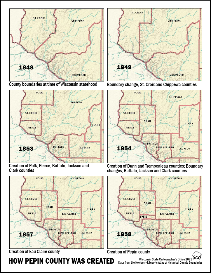
From a cartographic perspective, the shape of Pepin county is the result of a series of county boundary changes that date back to the formation of Wisconsin Territory in 1836. When Wisconsin achieved statehood in 1848, early county boundaries in the area were already established. At the time of statehood, modern Pepin County was part of Chippewa County, which at that time also included modern Eau Claire, Dunn, and Rusk counties (among others). The southern edge of Chippewa County was a stretch of the Mississippi River.
In 1854, Dunn County was carved out of Chippewa County. It included all of modern Dunn County as well as modern Pepin County including the Mississippi River stretch. In 1858, Pepin County broke off from the southern part of Dunn County. Dunn became landlocked, while Pepin retained access to the River. (See Map 1)
The funny “hook” shape of Pepin County is the result of its adjacency to the Mississippi River. In some ways it’s similar to the shape of northwest Pennsylvania around Lake Erie, which gives that state access to the Great Lakes, or to southern Alabama around Mobile, which gives that state access to the Gulf. Water transportation was the main commercial pathway in the years before the railroad and the Interstate. In the case of Pepin County, it’s not unreasonable to assume that access to the Mississippi River was highly coveted as a highway for the timber being harvested and sent down the Chippewa River. Despite this potential, Pepin County was never able to develop a significant Mississippi River port city.
County Boundaries in Wisconsin

As Map 2 shows, most county boundaries in Wisconsin are based on the Public Land Survey System (or PLSS) – a land partitioning system created after the Revolutionary War to convey federal lands to private ownership. The PLSS is the familiar pattern of one-mile by one-mile sections and six-mile by six-mile townships that cover the state today like a checker board. PLSS started in Wisconsin in the 1830s and took decades to complete.
You can look up the boundary definitions of Wisconsin’s counties in Chapter 2 of Wisconsin State Statutes online. For example, Dunn County, which Pepin County was once part of, is defined as follows: “Beginning at the southwest corner of township 26, range 14 west; and running east on the township line to the range line between ranges 10 and 11 west; thence north on said range line to the township line between townships 31 and 32; thence west on the township line to the range line between ranges 14 and 15 west; thence south on said range line to the place of beginning.”
Whenever you see a straight line county boundary in Wisconsin you can be fairly certain it is following a portion of the PLSS system, usually a township.
Water features like rivers also serve as county boundaries in Wisconsin. For example, Buffalo County is defined by three rivers: the most westerly channel of the Trempealeau or Mountain River, the main channel of the Chippewa River, and the Mississippi River, which is the Wisconsin-Minnesota boundary. The northern and eastern boundaries of Buffalo are based on PLSS.
As Map 2 shows, some county boundaries in the western part of the state are defined in part by rivers. Lake Winnebago is a slightly different story. The boundary shown between Winnebago and Calumet counties is an imaginary line dividing Townships in Range 17 and 18 East. This line was never surveyed over the lake.
Water boundaries are problematic because rivers change course over time. If the statute refers to the “main channel” of a river in the mid-1800s, there may be uncertainty about where that channel is today.
Native American reservations have also played a role. For example the boundary between Calumet and Fond du Lac counties is the “southern boundary of the Indian reservation” according to statute. Menominee County, which was created in the late 1950s and early 1960s, is a more complex example. Although defined in statute in terms of PLSS, the county was created to include ten townships then in Oconto and Shawano Counties that made up the Menominee Reservation.
County boundaries that are also state boundaries are not technically defined in terms of PLSS. Wisconsin’s state boundary is described in the state’s constitution.
One other anomaly on the map is the straight east-west boundary between Pierce and Pepin Counties. This may look like a PLSS boundary, but in statute it is described as a line running due east from the mouth of the Rush River.
Historical County Boundaries
The Newberry Library’s Atlas of Historical County Boundaries is probably the best source of map data on historic county boundaries in the US. The Wisconsin page of the atlas includes an interactive map covering the historical boundaries of all Wisconsin counties, including extinct counties and unsuccessful county proposals, from the creation of the first county through December 31, 2000.
The page also has a county-by-county index of boundary changes, a chronology of state and county boundaries, historical notes, metadata and (last but not least) shapefiles giving the full contents of the Atlas of Historical County Boundaries free of charge under a Creative Commons License.
The graphic that accompanies this article is based on the Newberry data. If you are interested in learning more about county boundary changes in the state, check out the Newberry interactive map, or download the shapefiles and make your own!