
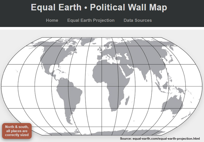
Last week, the United Nations General Assembly voted to endorse a new world map projection that properly displays countries and continents according to their actual size.
The projection – called Equal Earth – was developed by Bojan Šavrič (Esri), Tom Patterson (US National Park Service), and Bernhard Jenny (Monash University). It’s an alternative to other equal area projections of the earth, such as the Gall Projection (from 1855, later re-discovered by Arno Peters in the 1970s), the Sinusoidal (1500s), the Lambert Cylindrical Equal-Area (1772), the Mollweide (1805), Goode’s Homolosine (1923), the Eckert IV (1930s) and many, many others.
Equal Earth advocates argue that the projection is “a visually pleasing alternative to the Gall-Peters projection” and, while much like the Robinson Projection in appearance, is (unlike Robinson) equal-area.
The UN resolution is in part a reaction to continued use of the Mercator Projection, developed in 1569 for ship navigation. Esri, for example, continues to use a version of the Mercator Projection as the default for ArcGIS Online maps. Apple Maps continues to use it too. (Zoom all the way out to get the full effect.) Perhaps the most famous (and disliked) projection ever developed, the Mercator Projection grossly distorts land areas in the northern and southern hemispheres, giving more weight to North America, Eurasia and Antarctica.
But the thing about map projections is that there’s no such thing as a free lunch. This fact explains why there are so many equal-area projections in the first place.
In order to preserve area, equal-area projections must accept distortion in shape. All equal-area projections distort shape in some way. In the case of Gall-Peters, continents have a significant north-south stretching (depending on the spacing of the meridians). For Goode’s Homolosine, the earth is interrupted as if it were an orange rind flattened on the sidewalk. For Equal Earth, shape distortion is lowest at the intersection of the Equator and the Prime Meridian but increases as you move away from that point. North America, eastern Asia and Australia are visibly distorted.
The Mercator projection, while not equal-area, is conformal, meaning that shape is preserved. (Note that this property only exists locally, not over the entire earth. Technically, it is conformal at all locations on the earth, but for an infinitely small area at those locations.)
Conformality does have some utility, since linear distortion is the same in all directions at any given point. Thus the Mercator projection is widely used today in its transverse form to produce maps in the UTM (Universal Transverse Mercator) system. By limiting the projection to a 6-degree zone around a central meridian, UTM maps have very good distortion characteristics.
The Transverse Mercator is also the basis of WTM (Wisconsin Transverse Mercator) and many Wisconsin County Coordinate Systems (WISCRS).
Unfortunately, you can’t have a projection that is both conformal and equal-area at the same time. The UN resolution reflects a desire to prioritize correct areas over correct shapes, which is a laudable ideal given that maps impact our understanding of the world. Having a map that shows Africa in its correct size relative to the other continents can help dispel the myth that Africa is the same size as, say, Greenland, when it is actually much, much larger (30 million sq. km. vs. 2 million).
It’s just a cartographic fact that no map is free of distortion and that the types of distortions cartographers choose to accept depend on the purpose of the map, the audience and even broader societal objectives. But the language used to describe map accuracy is important – saying that a given projection “shows locations more accurately” is not nuanced enough, at least not for this cartographer.