
Geographic information is a strategic asset in Wisconsin. Yet, no systematic statewide approach exists for creating, maintaining, and accessing our geographic information – until now. The statewide strategic plan Wisconsin Location Matters, published under guidance of the Wisconsin Land Information Association (WLIA) in January 2007, underscored the need for statewide collaboration and cooperation, and identified the creation of the Wisconsin Geographic Information Coordination Council (WIGICC) as a top priority for our state. Through the persistence and dedication of Wisconsin’s geospatial community, the formation of WIGICC and a stakeholder Network is finally close at hand.
Currently, the WIGICC working group is facilitating the selection of members for an interim Council. Organizations and consortia representing functional sectors, as described in the WIGICC proposal to the Department of Administration, were asked to develop selection procedures appropriate to their organizations. Individuals nominated through these processes will serve as their sectors’ liaison on the Council. Currently, state agencies, federal agencies, and regional planning commissions have identified people who are willing to serve on the Council. Organizations representing the remaining sectors are expected to forward their nominations to the working group by the end of June.
The working group hopes to convene the interim Council by late summer, and to hold a statewide kick-off meeting of the Network shortly thereafter. In addition, the State Cartographer’s Office (SCO) and State Geographic Information Officer (GIO) are collaboratively developing a new WIGICC Web site, which will facilitate Network stakeholder communication through collaboration tools like blogs, wikis, forums and dynamic news feeds.
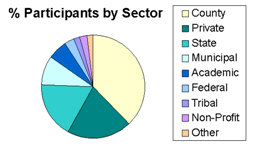
WIGICC listening session attendance
by sector (150 attendees).
Over the course of the next two years, WIGICC will develop a business plan and will address one or two key geospatial coordination issues to demonstrate the value of statewide coordination. Near the end of the two year period, it will seek formal recognition through executive order or statute, and will identify roles and build relationships between itself and other organizations in the state.
How did we get here?
In early 2007, the GIO and SCO jointly assembled a working group to facilitate the creation of WIGICC. Based on an evaluation of other states’ coordination councils, and on past experience with the Wisconsin Land Information Board (WLIB), the working group developed a set of criteria and two initial models to serve as starting points for discussion. From there, the working group hosted five facilitated listening sessions, an online survey, and a statewide “summit” to solicit ideas and feedback from stakeholders. People from all sectors participated in these discussions.
Based on the information collected, the working group concluded that creating an interim council for the next two years was the best course of action. The Wisconsin Department of Administration (DOA) endorsed the interim WIGICC proposal, indicating that it “strongly support[s] the idea of bringing people together to identify priorities, to seek opportunities to work together, and better coordinate activities.”
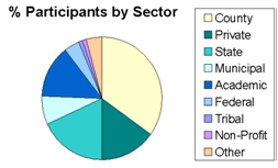
WIGICC summit attendance by sector
(85 attendees).
Draft WIGICC Proposal
The WIGICC proposal offers a model for coordination that is inclusive, representative, and participatory. The overarching goal of WIGICC is to give all stakeholders within the geospatial community a voice in statewide initiatives. Thus, the proposed model includes two equally important components – a Council and a stakeholder “Network.”
WIGICC Network
The stakeholder Network, once established, will provide an open forum for a wide range of stakeholders to communicate and to engage in the cooperative development and use of geographic information resources. It also will identify issues and make recommendations to the Council on appropriate actions and policies. Ideally, the Network will reach beyond traditional geospatial communities into communities such as emergency management, public health, economic development, and education.
“Communities of practice” are encouraged to form within the Network around common interests and needs. For example, the State Agency Geographic Information Coordination (SAGIC) team will be one of the Communities of Practice within the Network. SAGIC serves as the primary advisory group and forum for state agency programs, the GIO, and other interested groups that deal with the business and/or technical geospatial issues of state government. Other communities are in the process of organizing, such as federal agencies with active geospatial programs in Wisconsin, and the geospatial business community. Communities of practice may formulate issue papers, propose solutions, and review Council activities, as well as share knowledge and expertise within their own community.
Interim Council
Once assembled, the Council will serve as a leadership body that works to strategically coordinate geographic information resources so that they are applied effectively, efficiently, and equitably to meet local and statewide needs. The State Geographic Information Officer (GIO), working closely with the geospatial community, will seek ways to strategically implement the Council’s recommendations. The Council also serves as a conduit through which the interests and concerns of Wisconsin’s geospatial community can be directed to appropriate policy makers.
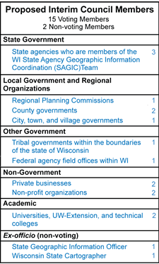
Fifteen voting-members will sit on the interim Council, including liaisons from local, county, state, federal, and tribal governments, regional planning commissions, academia, not-for-profits, and the private sector. The State Cartographer and GIO are non-voting members.
For more information on WIGICC and how you can participate in the Network, contact Lea Shanley at (608) 890-2456.