The Stoughton 1:62,500 topographic map (dated 1890) is one of the
oldest in the state. Download GeoPDF version of this map ![]() 5.34 Mb
5.34 Mb
The United States Geological Survey (USGS) announced on September 12th the availability of nearly 90,000 digital scans of historic USGS topographic maps. That number includes 2,851 maps of Wisconsin, some dating back to as far as 1889.
The historical maps are available to the public at no cost in GeoPDF format, or as a printed copy for $15 plus a $5 handling charge from the USGS Store. The GeoPDFs are georeferenced and can be used in conjunction with the new USGS digital topographic map, the US Topo. An extensive Users’ Guide explains the process for finding, downloading, and using the maps.
Two methods are available for locating maps: via the USGS store, and through a map name search. Both methods are detailed in the download instructions on the USGS Historic Topographic Map Collection Web site.
Interestingly, the historic topo scanning and preservation project has a number of strong ties to Wisconsin. Greg Allord, manager for the project, is based out of a Madison USGS office. In addition, the scanning for the Wisconsin topographic maps (along with several others states) was completed by the UW-Madison Robinson Map Library. Automated georeferencing of the maps was accomplished using “QUAD-G,” a software package developed by a team at UW-Madison including Dr. Jim Burt, Dr. A-xing Zhu, and Jeremy White.
While a USGS Fact Sheet on the new project makes mention of a GeoTIFF format, I could find no other specific information as to when that format will become available to GIS Users. With many more maps still to be released, I suspect we will see this additional format become available in the future.
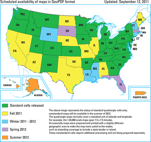
The entire country (200,000 maps total!) is expected to be complete and available for download during the summer of 2012.