
Over fifty years ago, Wisconsin Governor Gaylord Nelson recruited renowned landscape architect Phil Lewis to inventory the state’s cherished cultural and natural resources. Under the Wisconsin Outdoor Recreation Act and through community meetings with organizations and citizens throughout the state, a team of landscape architect students compiled a list of significant community resources. The goal of the project was to help legislators prioritize which parcels of land the state should purchase for protection in order to meet the growing demand for outdoor recreation.
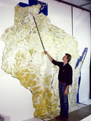
The original 12-foot tall map.
The process and purpose of the Wisconsin Landscape Resource Inventory is detailed in the 1964 Wisconsin Blue Book. The result of the project was an impressive 12-foot tall map that identified over 38,000 features as well as environmental corridors — areas with steep topography, floodplains, and riparian areas.
Creating the interactive map
Staff at the Center for Land Use Education (CLUE) decided to convert the Landscape Resource Inventory into digital format. CLUE is a joint venture of the College of Natural Resources at the University of Wisconsin-Stevens Point and Cooperative Extension in collaboration with UW System institutions. CLUE is a focal point for land use planning and management education, and creates learning opportunities for communities to help them make sound land use decisions.
The digital conversion was achieved by scanning, georeferencing, and digitizing the original paper maps. The maps were discovered deep in the Government Documents department of the UW-Stevens Point Library. The old maps contained county boundaries and major roads which were used as control points for spatially adjusting the scanned maps into real world coordinates. Over 38,000 features were manually digitized and attributed in a GIS database. Cultural and environmental resource points were represented using Lewis’ 220 original icons.
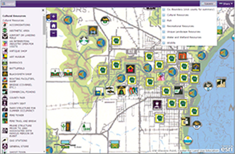
Wisconsin’s 1964 Landscape Resource Inventory Map.
As a way to commemorate the fifty-year anniversary of the 1964 map, CLUE developed an interactive web application for the map, with resource point icons as separate layers. This has made the data more accessible and easier to visualize. Users can now interact with the data by turning layers on or off, and by clicking on points to view their meaning rather than having to sift through a long legend. Dan McFarlane, CLUE GIS Specialist, was in charge of the project while Bill Troolin, a CLUE student intern, digitized and entered all the feature information.
Using the interactive map
In addition to honoring Phil Lewis’ important map, CLUE was interested in evaluating the impact of the original Outdoor Recreation Plan and the map’s influence on public land acquisition since the plan’s implementation nearly fifty years ago. The map can be used to measure the impact of the Landscape Resource Inventory on the prioritization of outdoor recreation planning and land acquisition. Using GIS, a proximity analysis revealed that a majority of public land acquisition since Lewis’ inventory targeted areas that were important to citizens. That is to say, public land acquisition was primarily targeted at areas with a dense concentration of icons. The histogram below shows the results of the proximity analysis.
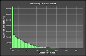
Histogram showing results of proximity analysis.
It is also important to see where changes have occurred on the landscape since 1964 as an indicator of success in education and planning throughout the state. Planners at the local and regional levels can benefit greatly from viewing and using this map in comparison to their own current and future land use maps.
A similar process could be re-created today, with the goal of identifying community assets on a map, determine if these original features are still there, and add to the ones that already exist. The resource inventory process that Phil Lewis utilized could be very useful in guiding land use decisions, tourism, and land preservation efforts. Obviously today with GIS, mobile, and web-based technology the process would be much more efficient and almost certainly less costly.
More information
For more information on this project contact Dan McFarlane by email or at 715-346-2573, or the Center for Land Use Education by email or at 715-346-3783.