The Bordner Survey
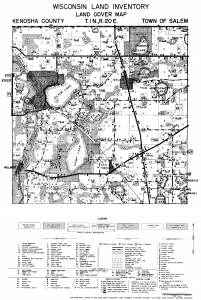
The impacts of the Great Depression in 1930s rural Wisconsin were amplified by the land use decisions made decades before. In northern Wisconsin most forested land had been cut, and attempts to farm this land often met with failure. Remediation efforts required accurate information about land use and land suitability, which led Wisconsin state government and the University of Wisconsin to collaborate on a detailed land inventory of northern Wisconsin. The effort was led by John Bordner, a Wisconsin farmer who earned a PhD in plant physiology in 1908. Bayfield was the first county completed by the “Bordner Survey” (technically the Wisconsin Land Economic Inventory), and by the mid-1940s, all counties except Milwaukee had been surveyed.
The survey’s level of detail was unparalleled. Field workers crossed the state at half-mile intervals, creating hand-drawn maps that were later compiled into maps for each six-mile by six-mile township. The township maps depicted agricultural and forest cover — including the types of crops grown, and the species, density, and diameter of trees — along with cultural and physical features.
Digitizing the Bordner Maps
The original Bordner maps have been scanned by the University of Wisconsin Digital Collections Center and are available online. Over the last decade, the Forest Ecosystem and Landscape Ecology Lab in the Department of Forest and Landscape Ecology at UW-Madison, under the direction of Professor David Mladenoff, has led the effort to digitize the maps. The digitizing process converts the scanned maps into an intelligent GIS database that can be used to support analysis and custom visualization. This digitizing work has been funded through the UW-Madison Graduate School, the UW-Madison College of Agricultural and Life Sciences, and the Wisconsin Alumni Research Foundation.
Recently the State Cartographer’s Office joined the project, and in 2016 the team received a grant from NOAA through Wisconsin’s Coastal Management Program to develop a coastal Bordner GIS database and geoportal for the coastal zones of Lakes Superior and Michigan in Wisconsin.
Coastal Bordner Survey Explorer
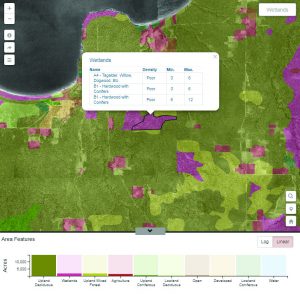
Under the Coastal Management Program grant, Bordner maps were digitized for the entire Great Lakes watershed and an online mapping application (called the Coastal Bordner Survey Explorer) was developed to support visualization and mapping. The application includes interactive capabilities to explore point, line and polygon features from the Bordner maps. It also provides access to georeferenced mosaics of a 1930s-era US Department of Agriculture air photo series for coastal counties. These photos are a useful counterpart dataset to the Bordner maps.
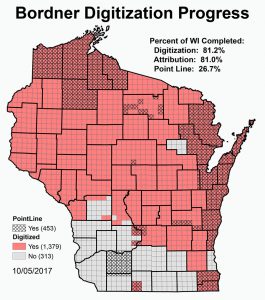
With the completion of the Coastal Management Program grant, over 80% of the land use polygons from the Bordner maps, and over 25% of point and line features, have now been digitized.
Data for the coastal areas of the state are available free for download on the Survey Explorer “about” page.
The project team continues to work toward the goal of completing the Bordner digitizing effort for the state and providing enhanced digital access to Bordner and other historic GIS data for Wisconsin. For a more complete description of this project see the project fact sheet.
The coastal Bordner map database and geoportal for the coastal zones of Wisconsin was Funded by the Wisconsin Coastal Management Program and the National Oceanic and Atmospheric Administration, Office for Coastal Management under the Coastal Zone Management Act,
Grant #NA16NOS4190108