
Background & Intent
A “cartographic phantom” is a community that appears on a map but does not actually exist on the ground. Phantoms often occur when small rural communities disappear but the map is not updated. The Geographical Names Information System (GNIS) – the official federal repository for geographic nomenclature maintained by the US Geological Survey (USGS) – contains a significant number of phantoms; these communities have remained in GNIS due to the comprehensive nature of the repository and the desire to not reclassify communities without strong evidence of their disappearance.
It is important to update GNIS because it is the source for unincorporated place names for the USGS’s digital topographic maps, called “US Topos.” Likewise, websites such as Google Maps use GNIS as a source of unincorporated place name data, as do other online and traditional map publishers. Consequently, upon close inspection of many maps, labels for non-existent unincorporated places are common.
The Wisconsin State Cartographer’s Office (SCO) has been working to map unincorporated places in Wisconsin for a number of years. Unincorporated places are recognized, named communities that are not officially incorporated. These places often become phantoms because they are small communities, often exist in areas of declining population, and are not actively monitored by state or federal agencies like the Census Bureau.
Recently, the SCO assembled over 600 potential cartographic phantoms in Wisconsin that are currently recorded in GNIS. Our goal is to assist the USGS update GNIS by identifying which of these places should be reclassified. We do not want the places removed from GNIS, but rather reclassified as “historical.” This will ensure that the places continue to be accessible for mapping purposes, but will allow for more refined cartographic treatment both on US Topos and other types of maps.
Methodology
Phase 1 of the SCO project implemented a simple mapping methodology to identify places that are unambiguously cartographic phantoms, in that they have no residential population of any size within a reasonable distance of the GNIS-defined location. This so-called “Fast Phantom Finder” method involves the following:
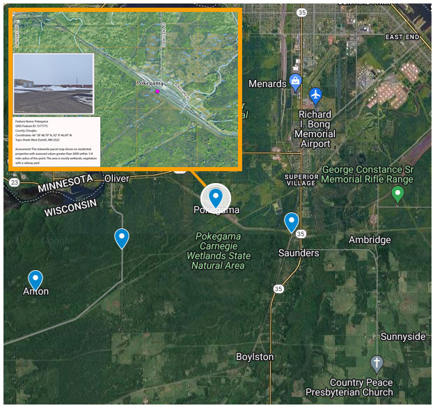
- The creation of a ¼-mile buffer around the GNIS-defined location. This is the same distance used by the Wisconsin Department of Transportation as part of the general criteria and guidelines used to recognize and provide signage for an unincorporated community.
- The selection of parcels from the Wisconsin Statewide Parcel Map that were: a) in whole or in part, classified as residential (e.g., purely residential, residential/commercial mix, residential/agricultural mix, etc.); and b) had an assessed value of improvements over $800. This value is used to filter out residential parcels without improvements, would therefore have no residents. We use a value of $800 rather than $0 to eliminate parcels that contain only non-inhabitable improvements such as a shed or garage. The resulting selected parcels we call “residential parcels.”
- A spatial join of the residential parcels and the buffer to compute the number of parcels within the buffer. The assumption is that areas with no residential parcels have no residential population and hence, no existing community. Therefore, those records with a count of zero are considered potential phantoms. We identified 58 potential phantoms from this procedure.
- Additional evidence, including visual inspection of imagery, consideration of anomalies (such as missing parcel data) and in some cases on-the-ground verification. This process pared the list down to 31 likely phantoms.
We need you!
These 31 likely phantoms can be seen on this simple Google Map (laptops or larger are more user friendly than phones). Clicking on a phantom reveals details of the feature as well as a URL which links to an image of how the feature appears on the most recent US Topo map. Our analysis and an on-the-ground photo, where available, are included in the image.
Before presenting these to the USGS for reclassification, we are reaching out to you – the users and creators of maps of Wisconsin – for your comments. Do you know anything about these phantoms? Do locals still refer to these places by name? Do they appear on the maps you make and do you plan to keep displaying them? Any information you can provide would be welcome!
Please contact Mike Hasinoff with your comments.