
 Have you ever wondered how often new place names are added to the map? Or how often place names change?
The term “toponym” refers to the proper name of a geographic feature, especially physical features like rivers, lakes, mountains, capes, bays, etc.
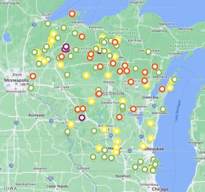
This map shows the geographic features in Wisconsin for which new names or name changes were approved by the U.S. Board on Geographic Names since the start of 2000. The date of 2000 bears no special significance, but it helps reduce the number of features on the map to a manageable total of 126.
This means that over the past 23+ years, on average, about 5.25 features per year in Wisconsin are renamed or receive a new name.
The Board on Geographic Names (BGN) is a federal body that maintains official toponyms for the nation. State bodies, such as Wisconsin’s Geographic Names Council, forward proposals for name changes and new names to BGN once they have been adopted at the state level. Once the have been reviewed and approved by the BGN, the names are entered into the Geographic Names Information System (GNIS).
What’s on the Map?
There are four categories of toponyms in the legend of the map.
“New name” means a new place name was added for a feature that was previously unnamed.
“Name change” means that the feature already had an official name, but the name was changed. Changing an existing place name only occurs if there is a legitimate reason to do so. For example, the place name might be shared with another feature nearby, causing confusion. Or, the name change might be required to correct a spelling error.
Place names are also changed if the name is offensive or derogatory. Names we would now consider to be derogatory were unfortunately all too common on maps from earlier eras. The BGN has long had policies against the introduction of new derogatory names, but for derogatory names already on the map, the onus is generally on an individual to identify and suggest a replacement.
There have also been several nation-wide systematic efforts to eliminate and replace derogatory toponyms. The most recent of these efforts was a 2022 program initiated by Secretary of the US Department of the Interior, Deb Haaland, who signed two orders creating administrative bodies to review and replace derogatory toponyms across the country. Secretarial Order 3404 focused on one particular derogatory term, a Native American slur, and created a Derogatory Geographic Names Task Force to find replacement names for features bearing this name on federal lands. The Task Force was established and chaired by the US Geological Survey (USGS), who made a list of candidate repalcement names available for public comment via the Federal Register. The final decisions on proposed name changes were finalized in September, 2022.
These name changes are shown on the map as a third category, labelled “Offensive name changed – Secretary’s Order.”
The fourth and final category on the map, labelled “Offensive name changed,” refers to additional derogatory name changes that were approved before the Secretary’s Order was written. These represent cases where an individual initiated a proposal to remove an offensive name from the map.
Each of the locations on the map has a host of attributes, visible when you click on the location: the feature’s current name, its GNIS ID (“Gaz ID”), the feature type or class (e.g., “stream”), the county it is in, the USGS topographic map it can be found on, its elevation and coordinates, the date when the name change or new name was approved by the BGN (“BGN Decision Date”), the date the feature was first added to GNIS (“Entry Date”), whether the approval was authorized by the BGN or the Secretary of the Interior Department (“Authority”), the reason for the change, the type of change, and the previous name if applicable.
How Was the Map Made?
GNIS contains all of the data needed for the map. As explained in the GNIS Help Page, users can run a variety of queries in GNIS to focus on the features and locations of particular interest to them. In my case, I chose “Board Decision” (i.e., BGN approvals) in the “Decision Authority” field for all features in Wisconsin, using a “Decision Date” after 01/01/2000. I downloaded this as a CSV file. I then did the same thing for “Secretarial Order” in the “Decision Authority” field to get the name changes resulting from Secretarial Order 3404. I joined the two CSV files together and imported it into Google My Maps, possibly the world’s simplest web mapping tool. I have written about My Maps before. It took only a few minutes to get a final (albeit simple) web map in place.
Wait a Minute…
One of the more educational aspects of this exercise was observing that, even though toponyms may be “officially” added or changed, there is no guarantee that map-makers will use the new names. Take a look at the Google base map used in the Wisconsin toponym map and see how many occurrences you can find where the old toponym is still displayed. This includes many of the derogatory place names that were eliminated in 2022 by Secretary Haaland’s order. Presumably, Google has yet to update all of its basemaps. This may be true for other map-makers as well. Another interesting question is whether these errors are isolated to certain states.
The good news is that, compared to paper maps, web maps — including the base maps produced by Google, Apple, and other companies — are much easier to update. These map providers also supply a mechanism for users to provide feedback about errors in their maps…
For users interested in digging deeper into BGN decisions in Wisconsin and elsewhere in the country, the BGN is now posting its quarterly review lists online showing the proposals pending before the BGN’s Domestic Names Committee.
Many thanks to Jennifer Runyon at the USGS for her assistance!