
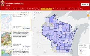
 The WGNHS (Wisconsin Geological and Natural History Survey) has introduced a new online Mapping Status Portal that allows users to browse the most up-to-date WGNHS publications and their coverage areas. The portal shows the reports, maps and GIS data available at any location in the state a user chooses.
The portal allows users to search through all WGNHS publications for an area of interest, or to focus on one map type: bedrock geology, surficial geology, water table, bedrock topography and other groundwater maps. Users can filter results by mapping scale, map status and GIS data status.
A single WGNHS publication may include multiple elements, including reports, map plates, data files and GIS data. The latter may include shapefiles, geodatabases, rasters and data exchange formats. Examples of GIS data available in different parts of the state include depth to bedrock, water-table elevation, wells, groundwater recharge, groundwater susceptibility, quaternary geology, bedrock geology and others.
The WGNHS is moving to a federal standard called GeMS (Geological Mapping Schema) for its GIS data products. GeMS provides a standard for encoding the content of geologic maps, focusing on the publication, transfer and archiving of map data. Older mapping projects, for which GIS data was not available or in an older format, are also being converted to GeMS, facilitating the utilization of WGNHS data for GIS analysis by planners, conservation professionals, state agencies, researchers and the public.
The WGNHS Mapping Status Portal was created by Hydrogeologist Amy Wiersma, GIS Specialist Matthew Rehwald, and Assistant Director for Technical Operations Peter Schoephoester. The portal was developed to make WGNHS publications, maps and data more accessible to users. More details on the portal can be found here.