
Note: This posting is based on materials presented by Jim Giglierano, Wisconsin’s Geographic Information Officer, at the Wisconsin Land Information Council (WLIC) meeting in February, 2023.
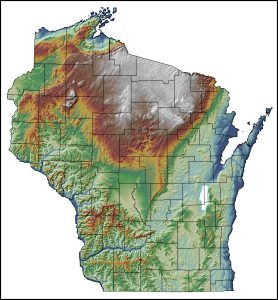
Wisconsin will achieve statewide publicly available LiDAR coverage in a standardized format by the fall of 2023. Statewide coverage was first achieved in 2018 but some of the data was not publicly available and there were no minimum standards in place.
By this fall, all 72 Wisconsin counties will have QL1 or QL2 LiDAR obtained through the US Geological Survey’s 3DEP LiDAR program. Sixteen counties will have QL1 data. QL1 and QL2 refer to “Quality Levels” that have specific accuracy and resolution parameters as defined by the 3DEP specifications. The table below summarizes these parameters.
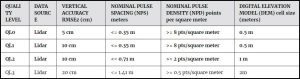
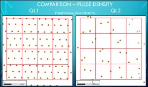
QL2 LiDAR has a resolution of at least 2 points per square meter, while QL1 data has a resolution of at least 8 points per square meter. Both QL levels have a vertical accuracy (Root Mean Squared Error or RMSE) of about 10 cm on a level surface. Increasingly, local governments and state agencies acquiring new LiDAR data are looking for even higher point densities and accuracy levels conforming to 3DEP QL0 or beyond.
The goal of 3DEP is to complete continental US QL2 coverage by 2024. Currently about 85% of the country is complete. The estimated cost of QL1 and QL2 LiDAR data for the state is about $15 million, with local (county) contributions totaling between $4-5 million. Wisconsin Land Information Program staff at the Wisconsin Department of Administration help coordinate the annual proposal to 3DEP with local Wisconsin partners. The largest federal contributor is the National Resource Conservation Service of the US Department of Agriculture.
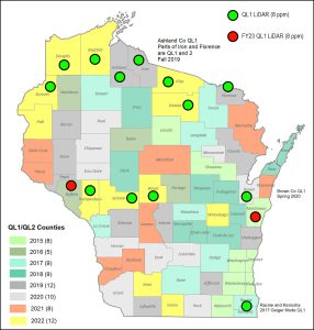
The map below shows the Fiscal Year 2022 projects to be delivered in fall, 2023 (in yellow). Fiscal Year 2023 awards for QL1 data are shown with red dots. The green and red dots show the QL1 counties.
As the 3DEP program completes its goals, future funding for LiDAR is uncertain, but improvements in technology are driving interest in new acquisitions. QL1 projects are becoming more routine and more above-ground uses like buildings, trees and powerlines are being identified. High priority areas — areas with big changes in land the surface, as well as urban and flooded areas — are likely to continue to be collected under 3DEP. There is also increasing interest in super high-resolution projects (e.g., 30 points per square meter). Topobathy and bathymetric acquisitions are also becoming more common, especially in coastal areas and ports.
LiDAR data is available from the WisconsinView repository via the State Cartographer’s Office map interface. It is also available from the US Geological Survey and can be streamed from a Wisconsin Department of Natural Resources map service.
Please note that, due to an often multi-year lag between data acquisition and data availability, some of the LiDAR projects shown on the status map above may not yet be available on WisconsinView or from the US Geological Survey.
For more information please contact Jim Giglierano at the Department of Administration.