
The term “Geovisualization” has crept into our vocabulary over the last five years. It can be heard at recent national conferences, seen in GIS newsletters, and is a priority for a growing academic research community. More recently, it also comes closest to describing a breed of software that is making a fresh splash in the market. This type of software is not new, but recent developments have garnered more media attention than usual.
This renewed attention appears to be due to several developments – better 3-dimensional perspective and imagery backdrops, much improved navigation and usability, Internet-based delivery of streaming information, and greatly reduced prices. What I’m referring to is cheap, easy-to-use software providing satellite and photo image-based backdrop, along with a 3-D perspective for viewing, navigating, annotating, and exploring layers of geographic data. So how is the user experience? Go ahead and try one out yourself.
“Geovisualization is both a process for leveraging these data resources (spatial data) to meet scientific and societal needs and, together with the broader discipline of Geographic Information Science (GIScience), a field of research and practice that develops visual methods and to support a wide array of geospatial data applications.”
Alan MacEachren et al. 2003. Draft Paper Submitted to Computer Graphics & Applications
Give Keyhole and WorldWind a try
Two of the easiest options to test-drive are the low-cost Keyhole GIS (now owned by parent company Google), and the free-to-download WorldWind available from NASA. To me, both are indicative of exciting new developments in easy-to-use visual interfaces and hint at the wider application of geographic and location-based information for everyday consumers.
They also point to the continuing need in the GIS industry to find standard, interoperable ways to deliver the visual and mapped results of geographic data and analyses to a growing audience of device platforms and software clients. Picture sitting on a park bench and zooming around on a 3-D map visiting nearby restaurant choices complete with interior photos, reviews, daily specials, etc. all from your cell phone. Geovisualization interfaces and software are really the foundation for the next generation of consumer location- based service (LBS) applications – applications tailored specifically to our personal location with timely information for making everyday decisions.
Cheap, visually pleasing, and easy to use
Keyhole GIS is not new, relatively speaking. The company and its technology debuted in 2001, and when they partnered with a major satellite data provider, they had the high-resolution imagery needed to complete global coverage and truly capitalize on their intuitive interface technology. Next, the company developed advance client and server-based software that allows customers to integrate GIS data and create custom data streams for Keyhole clients. Finally came its purchase by Google and reduction in the subscription cost for the easy-to-download-and-install client.
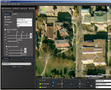
Keyhole GIS
I was able to download, install, register, get a temporary keycode for Keyhole 2 LT and begin navigating in about 10-15 minutes. With little assistance I soon found the search tab.. With the globe view spinning before me, I typed in my building address and was “zoomed” to a color aerial view of Science Hall. The layer manager boasts existing and intended layers of many categories of business and retail data as well as public services and points of interest.
Upon typing in a second address in Madison, I’m given a flight simulator style flyover moving from the first address to the second. Once I’ve found a place of interest, I can save a “placemark” for future reference or to send to another Keyhole user. Finally, after completing my tour, I can “playback” a recording of the places I’ve been.
Window to NASA imagery and web services
Worldwind is another software package worth giving a whirl. This software client is free to download from NASA’s Ames Research Center and has really helped to pique interest in the idea of WMS image services based on the Open Geospatial Consortium (OGC) standard.
The NASA client took me slightly longer to download and install, but all of that extra time was due to a slower download as the product is free and currently in high demand. As with Keyhole, right after installation, I was up and running, navigating throughout a 3-D Earth model using only mouse buttons to zoom and pan worldwide – it’s really easy !
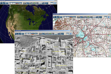
Worldwind is immediately a buffet of raster public domain NASA and USGS data through which you can easily navigate and over a given place toggle between say, the satellite image view, topographic map (DRG) view, and the 1-meter USGS digital orthophoto view. While I cannot type in a street address (as with Keyhole), I can type in my city name and be “zoomed” with similar flair to my city of interest. Worldwind also boasts functionality for displaying points of interest (e.g. MODIS Hotspots or Lewis and Clark Trail) that may be linked to additional images or a website location with more information.
Like Keyhole GIS, I believe part of the excitement over Worldwind has stemmed from the fact that it is both extensible and Open source software. That is, software users have the ability to add their own Web Map Service (WMS) data to the application and developers have the ability to open the source code and change the program to fit their needs. This provides a good demonstration of publishing geospatial data to a wider array of potential users.
Looking to the future
So, other than having a high “coolness” factor, what can we learn from these geovisualization packages? First, a quality user interface experience ranks at the top of my list – the easier, more intuitive, and more aesthetically pleasing it is to use, the more satisfying the results will be. Next, having seamless packaged data supplemented with streaming online updates and local information is key. Finally, cost-effective access to these software clients for doing simple spatially-oriented tasks like locating a retail establishment, finding directions, and getting a visual feel for a place before you get there. It is these types of benefits that will drive demand for and help improve applications utilizing geospatial information.
On a final note, one thing that occurs to me in the interest of the Wisconsin GIS community is that the only GIS data I have visually explored in Keyhole and WorldWind are public domain federal data sets or seamless data licensed from private geospatial data warehouse providers. Yet, the extensibility is there – I wonder how long it will take to see geospatial information from the Wisconsin Land Information Program appear inside these same interfaces.