
For more information
Visit the History of Cartography Web site, or to purchase the new volume, go to the University of Chicago Press.
Map lovers, take note. History of Cartography Project Director Matthew Edney recently announced the delivery of “twins,” otherwise known as parts 1 and 2 of their latest volume in the renowned History of Cartography series.
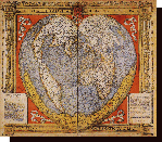
The new volume, titled “Cartography in the European Renaissance“, explores the period from 1450 to 1650, considered the most important in the history of European mapping. In the words of Dr. Edney, “[the twins] weigh 9lb 3.8oz and 8lb 0.8oz respectively, and together amount to lxxii + 2,180 pages. They are both 11.25″ tall, 8.875″ broad, and wonderfully straight of spine, but quite hairless (so we’ve given them beautiful jackets). I am also pleased to announce that through a breakthrough in science, these wonderful and long-awaited additions to the field of map history are to be cloned in multiple copies.”
To date, three of six planned volumes in the massive undertaking have been published. Work continues in parallel on two of the three remaining volumes, Cartography in the European Enlightenment and Cartography in the Twentieth Century. Cartography in the Nineteenth Century is still in the planning stages.
Based in the Department of Geography at UW-Madison, the History of Cartography project was originally conceived in 1977 by founding editors J.B. Harley and David Woodward as an ambitious multi-volume reference work that would examine the social production and consumption of maps across cultures from prehistoric origins to the twentieth century.
Source: History of Cartography Project, UW-Madison