
One of the more common questions we get at the State Cartographer’s Office (SCO) is “Where do I find ‘the’ school district map of Wisconsin?” In most cases, the call comes from an organization like a bus company, newspaper, or researcher who wants the latest statewide or regional view of school district boundaries. We rarely get calls from parents or realtors looking for individual district boundaries—those folks are usually contacting the school district directly for more information.
Many callers naturally assume “somebody” maintains a single, authoritative, up-to-date map showing the precise boundaries of every school district in our state. They are disappointed, of course, when I tell them no such map exists.
The reality is the majority of the 426 school districts in the state don’t have a detailed, up-to-date map showing their exact boundaries in a GIS or other digital format. They simply don’t have the staff or technology to maintain such a thing. They typically maintain the location of their school district boundaries using hard copy maps and/or some other format the district deems appropriate.
Options?
In order to better understand what’s available, I wanted to seek out some possible sources of school district boundary information.
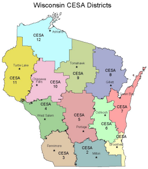
The first place I looked was the Wisconsin Department of Public Instruction (DPI) “Geographical Data and Maps” page available on their Web site. While they do show a generalized map of Cooperative Educational Service Agency (CESA) boundaries, I didn’t find any detailed or downloadable school district boundary maps on their site. The page mostly includes links to tabular information such as area calculations for districts, a list of districts by CESA, and a map of UW System campuses. All useful, but not what I was looking for.
With some further digging, I discovered DPI does publish a 22”x34” Public School Districts wall map. I called the DPI publications office, and learned the map shows color-coded school districts along with CESA boundaries. It does not show any basemap information such as county or municipal boundaries.
Thinking about other options, I then did a quick Web site survey of half the 12 CESAs in the state. Simply put, I didn’t find much in the way of school district maps. Any of the maps I did find appeared to be derived from the generalized statewide map produced by DPI.
Census School District Reference Maps
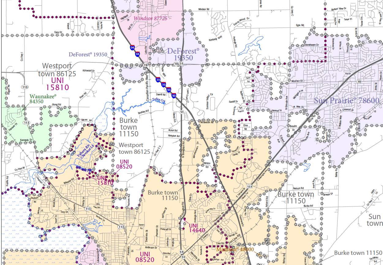
Example of a Census school district map for northeastern
Dane County, WI.
The U.S. Census Bureau recently published school district reference maps for the entire U.S. Visit their site and you can download PDF-format maps derived from their TIGER geographic data. Cartographically, these maps are not the most impressive in my opinion, but they do carry with them a certain level of “brand authority” by virtue of being produced by the U.S. Census Bureau.
How does the Census Bureau acquire boundary changes from states? The “ideal” process is spelled out in a flowchart published on their Web site. For the 2009-2010 update cycle, states were required to use the MAF/TIGER Partnership Software (MTPS), which is a customized PC-based software application offered by the Census Bureau to support their School District Review Program. MTPS allows participants to review, update and submit school district changes or corrections. According to the Guidelines for the MAF/TIGER Partnership Software, MTPS can import GIS datasets containing updated district boundaries. However, it appears spatial layers can be used only as “templates for digitizing the boundary changes into the MTPS” (MTPS Guidelines, pg 19), thus making the update process fairly labor intensive.
In Wisconsin, the U.S. Census Bureau obtains school district boundary updates from the Wisconsin Department of Public Instruction, through a designated “Mapping Coordinator.” DPI has very limited GIS capabilities at this time, so they rely heavily on the tools provided by the Census Bureau to record changes to school district boundaries.
Locals mapping district boundaries from tax assessment data
Based on current records in the Wisconsin GIS Inventory, 42 counties in Wisconsin maintain a school district map of some sort. However, of those 42, we don’t have any specific statistics on what methods counties are using to create and maintain their school district data.
I dug up some discussions that took place on the de facto state GIS listserv (“doa-loadinfo”) that happened back in 2007 and again in 2009. What I took away from those threads is school district boundary maps are in theory best derived from tax parcels and assessment data. For someone who is GIS-savvy, generating an administrative boundary from parcel data is a relatively straightforward operation.
Cheryl Zellmer, the Real Property Lister for Dane County, was kind enough to talk me through the general process for how school district boundary updates find their way into county tax records. When a boundary change is approved by school districts or through an appeal process to DPI, DPI notifies the affected counties and municipalities. She will receive official notices on individual parcels or groups of parcels, and then update county records while working in close cooperation with the affected municipal clerk(s).
Where are the maps?
Going on the theory that counties have the most current information, I browsed the Web sites of about a dozen random counties of the 42 who indicate they maintain school district data.
I tried to approach this from a citizen’s standpoint, and simply typed “school district map” in the search tool on each county Web site. Only in one case did a search turn up anything relevant. I then visited each county’s online mapping site, and in only a couple of cases was it possible to turn on a specific school district map layer. More typically, you need to click on an individual parcel to identify a school district.
So… what is “best?”
Everything I’ve said so far is very interesting from an academic standpoint, but what’s the bottom line? Based on what I’ve learned, this will be my response when I get a call from someone looking for school district boundary maps:
- Parents or realtors should contact the school district(s)—but call, don’t spend a lot of time browsing their site looking for a map because you probably won’t find one. When looking for parcel-level information, it’s always best to verify the information through county tax records available on county Web sites.
- For maps showing the extent of a school district, check the county land information Web site. However, based on my own experience described above, a phone call may be necessary to see if anything is available. The catch, of course, is that school districts commonly cross county boundaries.
- Use the Census school district maps, but with the understanding they are appropriate for regional views, not parcel-level detail (e.g., “In which district is my client’s new house located?”)
- Looking for digital data? If they have it, the local Land Information Officer will be the best choice for single districts, or all districts in a county. For statewide digital data, the only option is Census TIGER data, easily available through the Wisconsin Legislative Technology Services Bureau. No state agency in Wisconsin is currently maintaining detailed, county-generated school district data in a GIS-friendly format.
It’s been quite a quest learning more about how school district boundaries are mapped in our state, and I’m sure I have a lot more to learn!