
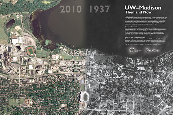
Just in time for the holiday season, a new 30″ x 20″ poster produced by the Wisconsin State Cartographer’s Office (SCO) uses historic photography to show how the UW–Madison campus has changed over time.
The poster blends a modern color photograph from July 2, 2010, with a historic black-and-white photograph from July 6, 1937. Historic air photos are a valuable resource for visualizing past landscapes and assessing environmental change. The photographs show the campus at almost exactly the same date, but across a span of 73 years. The poster highlights the dramatic changes that have occurred on campus and the surrounding community over this time period.
The methods used to construct the poster are similar to “looking into the past” or “time portal” pictures, which put historic photographs into present day contexts. Perhaps the most interesting examples of this genre are those produced by Russian photographer Sergey Larenkov, who merged World War II photographs into current photographs of the same locations; the results are awe-inspiring.
To construct the UW-Madison poster, the 1937 air photo was georeferenced to the 2010 photo using GIS software. A digital copy of the 1937 photograph was obtained from the Wisconsin Historic Aerial Image Finder, a joint project of the SCO, the Robinson Map Library, and UW Digital Collections Center. A copy of the 2010 photograph was obtained from WisconsinView. Both photos were originally acquired by the US Department of Agriculture; the 2010 photo is a one-meter resolution NAIP (National Agriculture Imagery Program) image.
For just $10, you can order the 30″ x 20″ poster rolled in a tube and ready for framing from the Wisconsin Geological and Natural History Survey (WGNHS) — in person (3817 Mineral Point Road, Madison), online, or by phone (608-263-7389).