
The University of Wisconsin-Madison and Wisconsin Department of Natural Resources (DNR) are partnering on a project to map the current vegetation, water, and urban patterns (“land cover”) of Wisconsin. The resulting digital database will replace a statewide land cover map created by DNR using 1991-1993 data.
One of the main drivers behind the land cover mapping project is DNR’s desire to improve whitetail deer habitat monitoring. The need for an improved statewide land cover database was specifically cited in a 2012 report by Deer Trustee Dr. James Kroll.
In addition, an accurate and up-to-date statewide land cover map will allow the DNR forestry division to map the distribution of tree types important to Wisconsin’s economy. More generally, land cover maps are used to monitor biodiversity, habitat loss, effects of climate change, and track land management decisions over time.
The project will run from May 1, 2014 to June 30, 2016 with funding provided by the U.S. Fish & Wildlife Service through the Pittman-Robertson Wildlife Restoration Act.
Mapping from Satellites
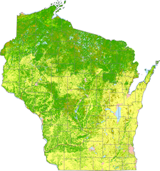
Using data from the Landsat series of satellites, the project team will map the occurrence of 40 or more different types of land cover commonly found in Wisconsin. At the most basic level, the state will be divided into broad “level 1” land cover classes such as agriculture, forest, wetland, and open water.
Each of these broad classes will be further subdivided into more detailed “level 2” sub-classes. The forest class, for example, will be further mapped as coniferous, deciduous, and mixed forests.
To the extent possible, the project team will also map certain species-level vegetation types such as Jack Pine, White Spruce, Maple, and Oak. The satellite mapping will be supported by extensive field work to gather training data and obtain accuracy assessment information.
Project Team
The State Cartographer’s Office (SCO) is coordinating the overall effort, and leading outreach and communication activities. A science team of experts from the UW-Madison Department of Forest and Wildlife Ecology is managing the technical implementation, with input from an external science advisory committee. Finally, the DNR is represented by a guidance committee of DNR specialists.
Get Involved
The project is in the earliest stages of development. One of our first tasks is to begin the process of reaching out to stakeholders who have an interest in using land cover data in Wisconsin. To that end, we’ve created two resources.
First, we established very simple land cover project page on the SCO Web site. In addition, we also started a e-mail distribution list for anyone interested in receiving periodic e-mail updates from the project team. To join, simply send a blank e-mail message to join-landcover@lists.wisc.edu and follow the instructions you receive via e-mail.
Much more to come
This is a large, multi-faceted project with many interrelated parts. We look forward to hearing from you as the project moves forward over the next two years! As the saying goes, stay tuned for more information.