
On March 12, 2015, the State Cartographer’s Office (SCO) hosted a one-day forum entitled, “Aligning County Surveying and Parcel Mapping Efforts in Wisconsin,” at UW-Stevens Point.
The Forum – free to all attendees – initiated a community-wide dialog about county surveying and tax parcel mapping activities in Wisconsin. The forum brought stakeholders together to begin to improve alignment, coordination, and prioritization of surveying activities and parcel mapping efforts within and between counties. These efforts are necessary to ensure that parcel maps are accurate, that gaps and overlaps do not occur along county boundaries, and that users are confident using parcel maps. This topic of importance due to recent legislation in Wisconsin setting the stage for increased public access to online parcel maps. This legislation has instructed the Department of Administration to develop an online statewide parcel map by 2017 by integrating county parcel data.
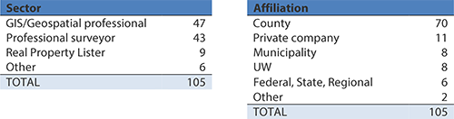
The Survey-Parcel Forum was a success. One hundred seventeen people registered and 105 (90%) attended. The breakdown of attendees by sector and affiliation is shown below.
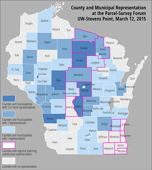
In terms of statewide distribution, the map below shows that county/municipal attendees came from a broad range of locales throughout the state. We attribute this in part to the fact that the event was held at a central location.
Our impression is that attendees found the Forum to be valuable, timely, and well-organized. We had excellent participation from attendees throughout the day, and have collected 30 flip charts of notes and ideas and over 100 scorecards, which we are currently analyzing and summarizing.
Our goal is to follow up on this event to keep momentum going. We plan to ask Forum attendees for their ideas on next steps, when we forward them the final Forum Report. This next step may take the form of another event, or it might focus on a tangible goal such as a specific funding proposal based on ideas generated at the Forum.
The SCO received a small Statewide Outreach Incentive Grant from the UW-Madison Office of University Relations to offset the cost of hosting the Forum. This funding is gratefully acknowledged.
The Forum ties into the SCO’s broader outreach mission. Most of the initiatives undertaken by the SCO are aligned to the “Wisconsin Idea” — which tries to leverage the expertise and resources of the University of Wisconsin for the benefit of the state’s citizens. Overall, the SCO’s goal is to use outreach and community engagement to help advance geospatial policy in Wisconsin. Only by engaging all stakeholders can we develop a common vision for the state and facilitate the adoption of this vision as a model for the future.