
The 2016 Geospatial Summit, held on April 19 at UW-Madison, attracted almost 140 registrants from locations around the state. While primarily an academic conference, there is strong interest on the part of government agencies, private companies, non-profits, and the general public. Representatives from various UW system campuses were also present, including a large contingent of faculty and students from UW-Platteville this year.
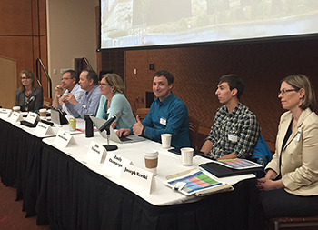
Education roundtable
This was the seventh annual Geospatial Summit. The event began in 2010 as a small gathering at UW-Madison to discuss the future of the Geospatial Alliance –- a group of Madison faculty, staff and students involved in the field of GIS.
Highlights of the 2016 Summit included:
An Educational Roundtable addressing the question: “What geospatial workforce skills are on the horizon and how is higher education responding?” Panelists included Joseph Kerski, Education Industry Curriculum Development Manager at Esri; Janet Silbernagel, Professor and Director of the Environmental Conservation Professional Masters Program, Nelson Institute for Environmental Studies, UW-Madison; David Hart, President, Continental Mapping Consultants; Emily Champagne, GIS Supervisor, Milwaukee Metropolitan Sewerage District/WLIA President Elect; John Czaplewski, Programmer/Analyst, Dept. of Geoscience, UW-Madison; Lisa Morrison, GIS Section Chief/Acting Agency GIS Coordinator, Wisconsin Department of Natural Resources; Fred Iausly, Senior GIS Analyst, Dane County Land Information Office; Ian Muehlenhaus, Program Director, Online Masters in Cartography/GIS Development, Dept. of Geography, UW-Madison.
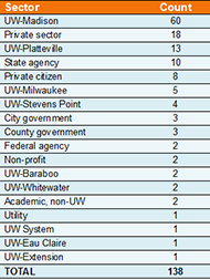
Summit registrants by sector
Fifteen research presentations by a diversity of speakers: David Gagnon, Wisconsin Institutes for Discovery, UW-Madison; Jim Giglierano, Wisconsin Dept. of Administration; AJ Wortley and Mitch Johnson, State Cartographer’s Office, UW-Madison; Ian Muehlenhaus and I-Pang Fu, Dept. of Geography and Division of Continuing Studies, UW-Madison; Chuck DeMets, Dept. of Geoscience, UW-Madison; Jo Ann Oravec, UW-Whitewater; Caitlin McKown, Bill Buckingham, and Malia Jones, Applied Population Lab, UW-Madison; Tanya Buckingham, Cartography Lab, UW-Madison; Math Heinzel, LICGF, UW-Madison; Carl Sack, Dept. of Geography, UW-Madison; Ben Zietlow, CFIRE, UW-Madison; Tim Kennedy, UW-Stevens Point; Sam Batzli, Space Science & Engineering Center, UW-Madison; Asligül Göçmen, Urban and Regional Planning, UW-Madison; Robert Reuschlein, Real Economy Institute.
A keynote address by Dr. Joseph Kerski, Education Industry Curriculum Development Manager at Esri. Dr. Kerski spoke on five converging global trends – geo-awareness, geo-enablement, geotechnologies, citizen science, and storytelling – and how these trends have the potential to offer GIS an unprecedented world audience. He discussed how GIS practitioners can seize the opportunity that these trends present to actively promote geospatial content knowledge, skills, and perspectives throughout education and society.
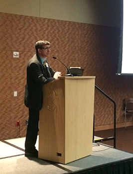
Dr. Kerski
We want to take this opportunity to thank Dr. Kerski and all of the Summit presenters and roundtable members, whose time and efforts helped make the event a success. Likewise we would like to thank the event sponsors who helped offset the cost of the event for the SCO. This year’s sponsors were Esri, the Nelson Institute, and UW-Madison Geography Dept. GIS Certificate Program.
For those of you unable to attend this year, we hope to see you at the 2017 Summit. Relevant information will be posted on the Geospatial Alliance and SCO websites as the date draws closer.
For those of you who did attend the Summit, please take a minute to fill out our online survey to help improve your experience next year.