
Wisconsin received two Esri Special Achievement in GIS (SAG) awards in 2016, one for the Statewide Parcel Map Initiative and one for Racine County’s new GIS system.
According to Tyson Fettes, Racine County Register of Deeds, the county’s new system better accommodates public needs by allowing users to easily tap into the system’s many functions. The (Racine) Journal Times quotes Fettes as follows, “Public users who utilize the GIS to look at their property lines or find foreclosures just don’t want to deal with layers or turning aspects of the map on and off….They want to accomplish a single task quickly, accurately and from any location, or on their mobile device, and our previous GIS simply didn’t meet this need.”

Racine County SAG award.
The new system can be accessed here. By simply clicking on one of the apps, users can locate a parcel, find a business park or indistrial site, get open GIS data, perform a plat of survey search, get election polling information, and much more. Each app is customized to do one thing well, rather than trying to roll all needed functions into a single app.
The top picture to the right shows Jack Dangermond, President and Founder of Esri, presenting the SAG award to Kim Christman, Racine County Real Property Lister and GIS Coordinator; Tyson Fettes; and Julie Anderson, Racine County Land Information Officer.
The bottom picture on the right shows Dangermond presenting the SAG award for the Statewide Parcel Map. Holding the award is Martin Goettl, UW Eau Claire Geospatial Technology Facilitator and President of the Wisconsin Land Information Association. With Goettl are: Tony Van Der Wielen, GIS Manager, Legislative Technology Services Bureau; Jordan Leonhardt, GIS Analyst, Sauk County; Kelly Felton, Sauk County Land Information Officer; Bill Cozzens, LIS Analyst, Waukesha County; Peter Strand, GIS Administrator, Eau Claire County; and Joe Fleischmann, Sauk County GIS Coordinator.
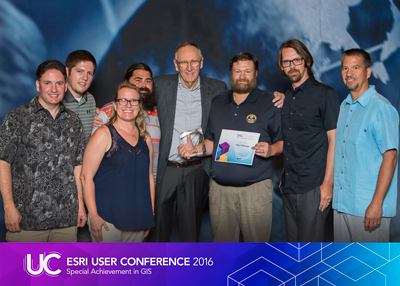
Statewide Parcel Map SAG award.
The Statewide Parcel Map Project was a cooperative effort between the Wisconsin Department of Administration, the State Cartographer’s Office, and Wisconsin’s counties and municipal governments who build and maintain parcel data. The first version of the statewide parcel database has been publically available online since 2015.
Congratulations everyone!
Note: other 2016 Esri SAG award winners are listed here.