
The Wisconsin Department of Military Affairs has published the state’s NextGen9-1-1 GIS Implementation Plan. The plan is available here.
The plan was developed as part of a larger NextGen9-1-1 (NG9-1-1) project with the Office of Emergency Communications (OEC) and consulting firm Geo-Comm, Inc. It outlines the tasks necessary for preparing local GIS data for call routing on an NG9-1-1 system.
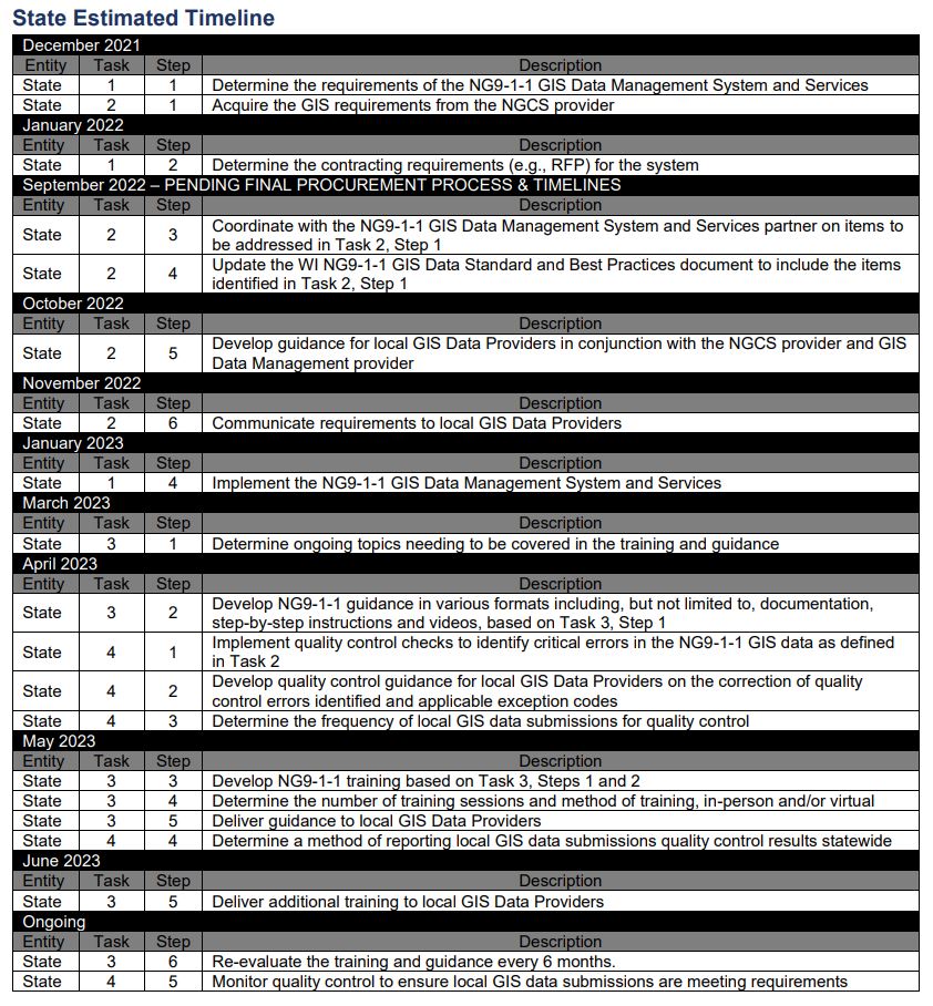
The plan covers implementation at the state and local levels. At the state level, the main tasks identified in the plan are:
- Implement an NG9-1-1 GIS data management system
- Acquire and distribute the NG9-1-1 GIS requirements from the NGCS (Next Generation 9-1-1 Core Services) provider
- Develop and provide continuous NG9-1-1 GIS data model training and guidance to GIS data providers
- Implement a continuous NG9-1-1 GIS data quality control program.
The report gives more details, including the steps associated with each task. The table below from the report shows the timetable for these state-level tasks.
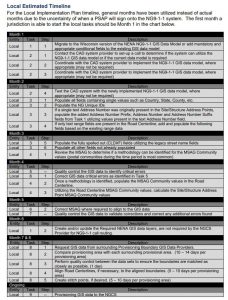
At the local level, the plan focuses on making data ready for NG9-1-1. The timeline is dependent on the resources available at each local entity, including the number of local or contracted staff, the actual number of attributes and mandatory fields that need to be populated, and the number and type of errors that need to be corrected. Tasks include:
- Migrate to the Wisconsin version of the NENA NG9-1-1 GIS data model (or add mandatory and appropriate conditional fields to the existing GIS data model)
- Coordinate GIS data schema updates with CAD systems (since the GIS data schema required for CAD systems may or may not align with the NG9-1-1 GIS data model)
- Populate mandatory and conditional fields with appropriate attributes
- Populate the MSAG (Master Street Address Guide) community for E911 compatibility (due to reliance on the E911 databases for transition and failover after transition to NG9-1-1)
- Quality control the GIS data to identify critical errors
- Correct quality control critical errors
- Quality control the GIS data to validate corrections and correct any critical
errors found - Perform edge matching with surrounding provisioning boundaries
- Provision GIS data to the NGCS (Next Generation 9-1-1 Core Services) provider
The table below from the report gives the estimated timeline for local-level tasks.
The NG9-1-1 GIS Data Standards and Best Practices Guide was released in November 2020. The guide was developed in conjunction with the Wisconsin Land Information Association (WLIA) NG9-1-1 Task Force and Geo-Comm to promote a common data model for NG9-1-1 GIS data layers across the state.