
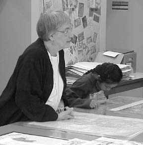
Mary Galneder explains a variety of maps to a group of schoolchildren visiting the Robinson Map Library.
For this issue we talked with Mary Galneder who has led the UW-Madison’s Robinson Map Library for the last 38 years. She will be retiring in August.
The library’s website is www.geography.wisc.edu/map_lib.htm
In the 1960’s there probably weren’t programs designed to train librarians to manage map collections. How did you get into this field?
I was studying for a master’s degree at Southern Illinois University and in my second year was given a graduate assistantship to work half time with the map collection there. That became a full-time job when I graduated. I spent some of those summers at the Library of Congress in Washington, D.C. helping there and culling extra maps from their collection that they were making available to universities.
How did your move to Madison in 1965 come about?
The job here became available, and through Washington connections Professor Arthur Robinson heard about me and asked me to apply. The library at UW-Madison had been in operation for a long time, primarily as a teaching collection, and had begun to grow substantially after World War II.
Did the Robinson name become attached to the library because he was its strongest proponent?
Professor Robinson was very supportive of the library, but I gather that through the previous decades the entire faculty depended on the map collection as teaching aids. The library was named for Robinson in 1982 in honor of his having become one of the main figures in American cartography.
You mentioned that the library had grown in holdings prior to your arrival. Did that trend continue through your tenure?
I estimate that the library’s holdings doubled over my years here. The greatest increase was in aerial photography. We now have over 230,000 individual aerial photographs. Most of these collections were donated by government offices which had acquired fresh photographs. We certainly have the largest collection of Wisconsin aerial photographs of any library.
While we do accept some minor donations from individuals, the other major source of acquisitions has been depository programs from the U.S. and Canadian governments, both civilian and military mapping organizations. We receive copies of all new maps produced by such organizations. Some of our USGS holdings go back into the nineteenth century. We now have over 275,000 maps.
How have things changed over the years, and what has stayed the same?
The biggest change has been the emergence of digital mapping and GIS. Of course this trend has just started and how it will change map libraries remains to be seen. Regardless, the printed maps in our collections will continue to be valuable resources even as some of them are transformed into digital format through scanning. We do have a scanner in the library that visitors can use to scan maps and aerial photographs.
What has remained unchanged throughout is a shortage of resources to manage all these materials.
In your retirement do you plan to travel with map in hand?
Oh, yes. I have plans to spend some time in the desert southwest as well as Europe. Madison will be home, though, and I have some special library projects here that I want to finish. One is an annotated bibliography of publications dealing with the management map libraries and their holdings. Another is a listing of Wisconsin place names that includes historical names that have not appeared on published maps for decades. And, I want to build a database to index the library’s collection of map postcards that people have sent to us over the years.
= = = = = = = = = Pullouts follow: I spent several summers at the Library of Congress in Washington The library’s holdings doubled during my tenure I have some special library projects to work on in my retirement