
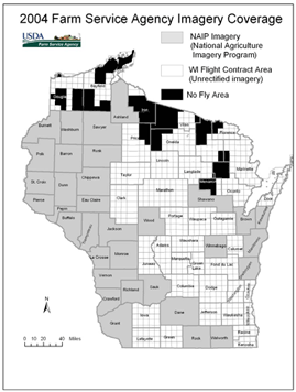
The National Agriculture Imagery Program (NAIP) provides color, leaf-on imagery on a yearly basis for implementing US Department of Agriculture (USDA) programs through the Farm Service Agency (FSA). Thirty-three Wisconsin counties will be flown under NAIP in 2004 for the first time. Another 35 counties will be flown with unrectified digital imagery under a separate contract. For further information, refer to: 2004 WI Farm Service Agency Imagery Programs
Larry Cutforth, GIS Specialist for the Farm Service Agency in Madison, is organizing a partnership looking to obtain 1-meter imagery statewide in 2005. The suggested partner contribution is $6 a square mile, which equals a contribution of $3,000 to $7,000 for most Wisconsin counties. The partnership group is exploring the possibility of obtaining direct digital imagery with an additional infrared band. Contact Larry Cutforth for further information (Larry.Cutforth@wi.usda.gov; 608-662-4422 Ext 139).