
UW-Extension’s Center for Community Economic Development is introducing a new publication that takes a spatial perspective on Wisconsin’s economic conditions. Mapping Wisconsin’s Economy will be published six to eight times per year, with each issue examining a different topic vital to economic and community development.
The goal of this new publication is twofold. First, each issue intends to educate economic development professionals, community leaders and educators on economic trends and their ranging impacts on regions and communities. Second, the overall series of publications aims to show how GIS and spatial analysis can be used as a tool for policy analysis and developing economic development strategies or initiatives. As education is the primary focus, each publication includes an accompanying narrative that describes the series of maps. This discussion examines the reason for mapping a particular data set, the methodology used to create the maps, and where readers can find additional information on the topic.
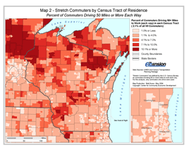
Figure 1: Stretch Commuters by Census Tract of Residence: Percent Driving 50 miles or more each way
Mapping Wisconsin’s Economy is available online at www.uwex.edu/ces/cced/mwe. To facilitate a number of possible uses, the publication includes both maps and data that can be freely obtained. The downloadable maps will be available in both PDF and JPEG formats. Furthermore, each issue will have spreadsheets that include additional datasets highlighting the attributes of individual communities and regions.
The first issue of Mapping Wisconsin’s Economy examines the potential impact of rising gas prices on Wisconsin’s commuters and communities. Using the recently released Census Transportation Planning Package and GIS analysis, several maps were generated (see Figure 1) to examine regional variations in commuting distances and the subsequent costs on employees. Future topics will include the loss of college graduates in the State (“brain drain”), the identification of regional industrial clusters with GIS and exploring the potential impacts associated with the impeding retirement of baby-boomers. The next issue of Mapping Wisconsin’s Economy examines some implications of the spatial distribution of per capita incomes and will be released in August.