
Introduction
In 1998, the Wisconsin Department of Transportation (WisDOT), in cooperation with the National Geodetic Survey (NGS), initiated a program to improve elevation control data throughout the State of Wisconsin. Beginning with small pilot areas, procedures, techniques, and technologies were tested to determine the best approach for modernizing the vertical component of the geodetic network.
Based on the results in the pilot areas, the two agencies have been moving forward on efforts to complete Height Modernization statewide. At a regional forum held in Madison in 2001, the major conclusion by participants from throughout the upper Great Lakes region was that Wisconsin had designed an excellent program; they just needed to speed up implementation. Therefore, WisDOT prepared the Wisconsin Height Modernization plan in 2003 that included several options, with completion dates ranging from 2008 and 2013, depending on funding availability. Recent increases in federal earmark funds, if continued for another three years, will provide the support needed to complete the program by 2008.
Phases of the WI-HMP
WisDOT has divided the state into eight phases (or regions), with most phases containing 10-12 counties. The phase boundaries depend on both topography and pre-existing NGS level lines (a series of bench marks for which vertical elevation has been established). Each phase lasts over three years, with planning and monumentation in year 1, GPS and leveling field observations in year 2, and the analysis, adjustment, and publication of data (by NGS), in year 3. To date, 4 of the 8 phases have been completed. Stations monumented during these early phases are accessible through the State Cartographer’s Office online ControlFinder application and on the NGS website.
Phase 5, in the southwestern part of the state, is the largest phase in terms of area, involving over 11,000 square miles and all or part of 23 counties. (See Figure 1) Contractors and WisDOT are in the field this summer, carrying out GPS and leveling observations for this phase. Phase 6, in the west central part of the state contains over 10,000 square miles and involves all or part of 17 counties.
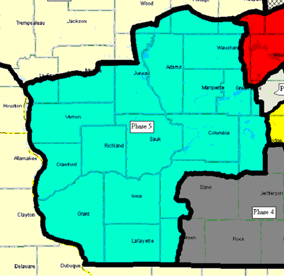
Figure 1: Height Mod. Program Region 5
Work began in Phase 6 in the fall of 2003. The first step in the planning process is to review the data in the National Spatial Reference System (NSRS) for existing geodetic monuments. Next a field check is made to verify that that the selected NSRS monuments still exist. In early Phases of the WI-HMP, we have found that about 50 percent of the NGS bench marks have been destroyed by construction and other development activities. This is the major reason that all users of the geodetic network are urged to file "mark recovery forms” with NGS each time they find and use a monument in the field. The recovery forms can be filed directly on-line
Once the field review is completed, WisDOT geodetic surveyors return to the office and develop a plan for the geodetic network for the phase. The network plan contains two major components: densification of the horizontal network and addition of new level lines containing new bench mark monuments. The densification from the horizontal High Accuracy Reference Network (HARN) involves the addition of primary, secondary, and local monuments in counties where this work was not competed earlier. For the vertical component, level lines, at a nominal grid spacing of about 25 kilometers are laid out, with bench mark monuments spaced every 3-4 kilometers along each level line.
When the network plan is completed, WisDOT surveyors return to the field and place lathe at the suggested location for each horizontal monument and each bench mark monument. At this point they may make changes in the plan, based on specific conditions they find in the field.
County Informational Meetings
The next step is to alert local government officials of our tentative plans and ask for their suggestions as to any change that might be needed. For the past three years, WisDOT and NGS have worked with county Land Information Offices (LIOs) to hold countywide information meetings to discuss plans for the network and seek the advice of local government officials. Active participation by local officials helps to assure that the newly established monuments are placed in locations that minimize their damage or destruction from construction activities. At these meetings, WisDOT outlines tentative plans for monument locations and solicits information about building and realignment of roads, utilities, and other construction activities that might result in the destruction of, or otherwise make monuments unusable in the future.
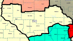
Figure 2
WisDOT and NGS met with counties in the Phase 6 area in May of this year. (See Figure 2) LIOs are the primary contact between the State and local government regarding the WI-HMP. However, they are asked to invite key individuals involved with elevation data plus anyone interested in local government infrastructure and GIS/LIS systems, including the County Surveyor, County Highway Commissioner, County Board Chair, County Committee Chairs, Town Chairmen, public works and engineering officials from cities, and elected State Representatives.
The meetings this year were generally well attended. A special effort was made to encourage town chairmen to attend, which resulted in much better participation. It is important that town officials have a good understanding of the WI-HMP, since they are often the first person local citizens contact with questions about field surveying activities they see in their neighborhood.
The next series of county informational meetings about the WI-HMP are planned for Phase 7, the northwest corner of the state, in 2005. Plan to attend a Height Modernization Program meeting when one is held in your county. For additional information about the County Informational Meetings or the Wisconsin Height Modernization Program in general, you can contact us at either:
David Moyer, NGS, or Darin Henkel, WisDot Height Mod. Program Manager