The U.S. Census Bureau is in the midst of an extensive project to improve the quality of data it will use to conduct the 2010 Census. The data being enhanced are the TIGER (Topologically Integrated Geographic Encoding and Referencing) database and the MAF (Master Address File) database.
The TIGER database, which can be displayed in map form, shows the type, location, name and relationship of streets, rivers, railroads, and other geographic features to each other. The MAF database is a complete and current list of all addresses where people live or could live, and the addresses and locations of where people work or could work.
The TIGER/MAF Accuracy Improvement Program, begun by the Census Bureau in 2002 for a six year period, aims to improve the currency and accuracy of these databases to the point where they can be used and maintained with the tools of modern technology, such as Global Positioning System (GPS) receivers.
Improved accuracy is key
Over the years, the TIGER database has been notorious for poor positional accuracy. Since the Census Bureau intends to have field enumerators use handheld GPS devices to collect and record data in 2010, it needed an up-to-date and positionally accurate database to store the new information. To do this, Census is using a variety of methods including the collection of locally produced street centerline files for integration into the TIGER database. The Census Bureau’s Regional Office in suburban Chicago coordinates this work for Wisconsin, Illinois and Indiana. Gail Krmenec, Census Regional Geographer, in the Chicago area office says that, “Overall, I think the State of Wisconsin has been progressing quite nicely in terms of local file acquisition for the TIGER alignment process.”
Local files acquired by Census are evaluated for completeness and positional accuracy. Tests are made on these files by comparing GPS collected coordinates at a well defined point on the ground (e.g. a road intersection) against the coordinates of the same point in the local file. If 95% the file’s tested coordinates are within 7.6 meters (approximately 25 feet) of the field-collected coordinates, then the file is accepted by Census as meeting the accuracy test, and then entered into the TIGER database. Private contractors hired by the Census Bureau collect the field point coordinates. Unfortunately these values become the property of the contractor and are not shared with the local organization supplying the file.
If a county’s files do not pass the positional accuracy test, or if the county has no road centerline files to share, Census assigns this county to its prime contractor on the TIGER Improvement Project. Harris Corporation, which holds the contract, collects the centerline data either by creating alignments from digital orthophotos, or from GPS points collected by driving all roads/streets in the county.
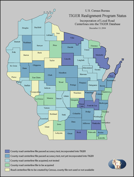
Wisconsin’s current status
In Wisconsin, the road/street centerline files of eight counties have been added to the realigned TIGER database. Another nineteen counties have passed the positional accuracy test, and will be added to TIGER soon. Files from another 22 counties have been acquired, but not tested. Finally, ten counties have either failed the accuracy test, or their files are based on data (e.g. U.S. Geological Survey Topographic Quadrangles) that clearly will not meet the accuracy test.
The next public release of the TIGER Line files is scheduled for January 2005. The release will include some of the counties that have been realigned; however, the list of Wisconsin counties in the 2005 revision has not yet been released by Census.