
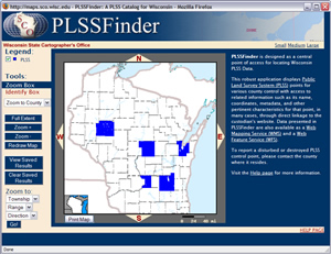
Designed as a central point of access for locating Wisconsin Public Land Survey System (PLSS) corner information, “PLSSFinder” is now online and available for public access from our Web site (www.sco.wisc.edu).
PLSSFinder displays PLSS corners for select counties, and provides access to related information such as corner ID, published coordinates, point of contact, and other pertinent characteristics. Most appealing perhaps is the direct linkage, in many cases, to county Web sites for tie sheet information.
To date, six counties have contributed data to PLSSFinder: Columbia, Dodge, Fond du Lac (township), Portage, Brown, and Chippewa. Currently in progress is Barron County with interest expressed from Rusk, St. Croix, Oconto, Sauk, Price, Jackson and Shawano counties.
We presented a demonstration of PLSSFinder at the Wisconsin Society of Land Surveyor’s Annual Conference in January, and received great feedback from attendees and surveyors. Overall, we heard that PLSSFinder will be a good gateway resource for locating PLSS information in Wisconsin, and aid counties that do not have the capability to provide similar access on their own.
Status of PLSS
The federal government was responsible for establishing the PLSS, but it is not responsible for ongoing maintenance. By state statute, counties act as the custodian for PLSS corners within their boundaries. This statutory authority was not supported with state funds, so most remonumentation has been completed with local revenues. Some of this work has been done by county surveyors and/or private surveyors on contract with local governments.
Progress towards updated PLSS monuments and coordinates has varied widely across the state, with some counties having completed remonumentation, while others are at various stages of completion.
Currently about 20% of Wisconsin’s counties have put their PLSS information online through their own custom Web applications, with another 20% slated to be accessible via PLSSFinder. This leaves about two thirds of the counties with no online access to PLSS information.
Next steps
In addition to improving the cartography of our reference layers, we are working on providing the ability to display PLSS corners that do not yet have updated coordinates, but do have other available attributes such as a historical tie sheet. We are looking to add links to those county Web sites that already provide online access to their PLSS corner data.