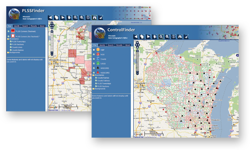
The Wisconsin State Cartographer’s Office (SCO) recently launched new versions of its popular ControlFinder and PLSSFinder applications, providing users with new functions and enhanced cartography.
The new Finder applications are built on open source software, including the GeoMoose web application framework, the OpenLayers Javascript Library, JQuery Javascript functions, the MapServer mapping engine, and a PostGIS/Postgresql database system for storing spatial data. The new apps make use of the Google Maps API for base map display, providing consistency with other modern web-mapping applications. Enhanced features of the new Finder apps include:
- Improved cartography, including better visualization of point and line symbols for geodetic control, PLSS corners, and PLSS and county linework.
- Clearer visualization of point ID numbers on the map for selected points.
- Better search functionality, including the ability to search by feature name, county, PLSS feature, and point attributes.
- Enhanced navigation functions for zooming and panning.
In addition, the use of Google maps and open source software allows us to make use of modern software tools and methods that will provide the flexibility needed to add or modify functions and features over time.
The SCO has been involved in cataloging and disseminating information about geodetic control and PLSS corner points since the 1970s. We developed ControlFinder and PLSSFinder as free, online catalogs designed to help users quickly and easily locate information for Wisconsin. Control and corner point information for these applications comes primarily from county contributors, with additional data supplied by federal and state datasets. Currently 21 counties participate in PLSSFinder and 15 counties participate in ControlFinder. In addition to local control established by counties, ControlFinder includes Wisconsin Height Modernization Program control, National Geodetic Survey (NGS) control, historic US Geological Survey 3rd order vertical control, and the NGS and Wisconsin Department of Transportation CORS (Continuously Operating Reference System) networks.
Both applications provide links to online digital tie sheets where available, and to information maintained by the NGS and participating counties on their own websites.

