

Recent events such as the catastrophe in New Orleans and water pollution around the country highlight the importance and functionality of wetlands for shoreline protection, flood control, water quality protection, wildlife habitat, and recreation. Unfortunately, wetlands are vanishing, and in Wisconsin only half of the 10 million acres present before statehood in 1848 now remain.
The responsibility for the protection and management of wetlands primarily falls to the Wisconsin Department of Natural Resources (WDNR) and wetland mapping is legislated through the Wisconsin Wetland Inventory (WWI). In January 2006 ten legislators requested the Joint Legislative Audit Committee conduct an evaluation of the WDNR’s wetland permit program. In May 2007, the committee released its report and recommendations, including several related to wetland mapping. These maps are used to help identify wetlands regulated by local governments under shoreland-wetland zoning laws, and serve as a starting point to help landowners and local governments determine whether wetlands may be present at a particular location.
The report sets forth a series of recommendations regarding the permitting process and wetlands protection. It highlights areas of recent improvement such as decreasing permit turnover time, and reducing the rate of wetland losses. The audit goes beyond the initial scope of the review and by including comments regarding wetland mapping. The four key findings are:
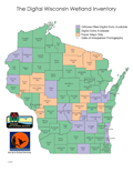
- WDNR wetland maps are outdated – maps in 33 counties are derived from aerial photos taken before 1986, and no wetland map is based on photos more recent than 1999
- Digital wetland maps are available for only 57 of the state’s 72 counties, and these digital versions are not available on the Internet
- More accurate maps are needed to help landowners determine whether wetlands exist on their property
- Local governments and nonprofit groups through expanded partnerships could assist with wetland mapping
To their credit, WDNR staff have previously identified many of these issues as problems and has already moved to address them. For example, state law requires wetlands maps to be updated at a minimum every 10 years, but the mapping inventory is now on over a twenty year cycle.
According to Lois Simon, the WDNR’s WWI Coordinator, this drastic discrepancy is due to current mapping funding levels that only allow about three counties a year to be updated and digitized. None-the-less, several counties have already been updated using newer aerial photography.
Since the audit the WDNR has also addressed other recommendations. As we reported in an October article, digital wetlands maps have been added to the WNDR’s Surface Water Data Viewer Web site. Through this service, maps are now available for many counties, a good step towards making them more available to the public.
The WDNR is in the process of making connections with existing mapping partners. The Southeastern Wisconsin Regional Planning Commission (SEWRPC) (covering seven counties: Kenosha, Milwaukee, Ozaukee, Racine, Walworth, Washington, and Waukesha) has contracted with WDNR to conduct their own wetland mapping for use in the WWI. SEWRPC has completed 2005 ortho-rectified maps for Ozaukee and Milwaukee counties, and plans to complete the remaining five counties soon. They then anticipate updating their wetland maps on a 5-year cycle. This has been possible because SEWRPC provides additional funding and has in-house mapping services. The WDNR’s emphasis on coordination is also reflected in their efforts to work with the NRCS to create a “wetland indicators” map based on hydric soils, vegetation, and hydrology. Such a map would allow users to be able to better identify wetlands without going into the field.
Both representatives at the WDNR and the Wisconsin Wetland Association, a statewide non-profit group focused on wetlands protection, stressed that wetland mapping is still not a substitute for field identification and delineation. A common misconception is that if a wetland does not appear on a map it does not exist. Current specifications require mapping wetlands larger than five acres; however some of the DNR’s maps show wetlands as little as two acres in size (which does not include seasonal wetlands). These smaller wetlands, however, are still subject to the same laws as larger ones, thus correct delineation is critical.
Overall, the audit highlights the current condition of wetland mapping in Wisconsin, and provides useful suggestions for further improvement. Mapping is an important tool, but more funding and a broad approach is need for protection of this dwindling resource.