
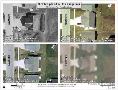
Orthophoto resolution comparison at a printed map scale
of 1″ = 50 feet. View the full-resolution version
Among the speakers at the recent Wisconsin Regional Orthophotography Consortium (“WROC”) workshop in Menasha, Adam Dorn with the City of Fond du Lac gave an excellent presentation on the city’s use of imagery for a variety of applications. Fond du Lac is one of a few municipalities in the state that has acquired 3-inch resolution imagery… pretty amazing stuff!
One of his handouts really caught my attention– a side-by-side comparison of 1-foot, 6-inch, 3-inch, and one meter resolution orthophotography over the same geographic area. According to Adam, they created the comparisons to help staff better understand orthophotos, and develop a more informed opinion about what product will support their needs.
I thought these would be of interest to a lot of folks around the state, so Adam gave me permission to distribute his handouts to anyone interested. They are definitely worth a look!
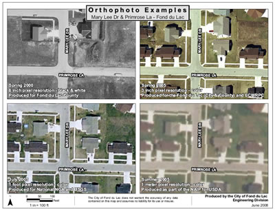
Orthophoto resolution comparison at a printed map scale
of 1″ = 100 feet. View the full-resolution version