
For more information
David Hart
GIS Specialist
University of Wisconsin Sea Grant Institute
(608) 262-6515

The University of Wisconsin Sea Grant College Program is sponsoring a new project at UW-Madison that will develop a geospatial data portal for coastal areas in Wisconsin. The Wisconsin Coastal Atlas (WCA) is envisioned as a way to make geospatial information more readily available to decision-makers as they address a wide range of coastal zone management issues in the state.
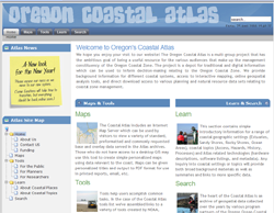
The design of the WCA will be based on concepts from the successful Oregon Coastal Atlas, refined through interaction with Wisconsin coastal science and management communities. The Oregon Coastal Atlas was developed by the Oregon Coastal Management Program in cooperation with Oregon State University and other partners beginning in 2000. It is organized into four useful sections – maps, tools, learn, and search.
For the Wisconsin atlas, the primary web mapping interface will provide an overview of the Wisconsin coastal zone. A gallery of additional mapping interfaces will provide customized perspectives related to specific coastal issues. The WCA will allow users to search a catalog of coastal geospatial data. The catalog for the atlas will connect to distributed catalogs maintained by other data custodians, allowing discovery, assessment, and download of a network of coastal geospatial data.
In addition, the WCA will serve as a gateway to spatial decision support tools relevant to the Great Lakes and as a site to learn more about coastal issues and places. It will be built with an open architecture and accessible design specifications to allow addition of tools and components over time from stakeholders.
Besides building the framework for the atlas, the project will tackle six research topics that address the science needed to effectively build and link coastal web atlases. These include: 1) structured design and evaluation of web atlases; 2) guidance on making choices among different web mapping technologies; 3) promotion of sound cartographic design principles for web mapping interfaces; 4) principles for development of domain spatial data infrastructures; 5) development of effective archives for coastal geospatial data; and 6) application of ontology tools to promote semantic mediation of local government spatial data sets to conduct spatial analyses of coastal issues at a regional scale.
Dr. Stephen Ventura (UW Land Information and Computer Graphics Facility) will lead the project team that includes staff from the UW Sea Grant Institute, UW Land Information and Computer Graphics Facility, the Wisconsin State Cartographer’s Office, the Robinson Map Library, and the UW Cartography Lab. Oregon State University and the Oregon Coastal Management Program will assist with additional guidance and support.
The official start of the project is February 1, 2010 and, as the project gets underway, the team will actively seek partners to help build the atlas. Besides providing access to the data that will make the atlas work, partners will benefit from access to decision support tools and data provided by other partners.
Since 1994, the University of Wisconsin Sea Grant Institute and the Land Information and Computer Graphics Facility at the University of Wisconsin-Madison have worked together to apply geospatial technologies to better understand coastal management issues facing the Great Lakes. An important objective of the Wisconsin Coastal GIS Applications Project has been to leverage the sizeable investment in local government land information systems in Wisconsin (over $152 million since 1991) and integrate local data to support decision-making about Great Lakes coastal management at a regional scale.
Source: UW-Madison Sea Grant Institute