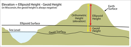
The State Cartographer’s Office recently published a new “Understanding Elevation” infosheet aimed at educating geospatial professionals on the often-misunderstood topic of elevation measurements. This is recommended reading for anyone collecting or mapping features in the field with GPS receivers.
The two-page infosheet gives a quick primer on vertical datums, followed by an explanation of the differences between ellipsoid, geoid, and orthometric heights, and how GPS receivers interpret each of these. The National Geodetic Survey “GRAV-D” project is also described, and how it is expected to improve elevation computations in the future.
The Understanding Elevation infosheet is one of a series of free technical publications on a variety of mapping/GIS topics. For a complete list of other SCO infosheets, check out the publications page on our Web site.

