
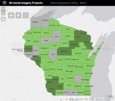
I recently put together a simple interactive Web map that shows recent and planned aerial imagery projects happening in Wisconsin. The goal is to help folks understand the scope of what’s happening next year, along with projects that occurred in 2013-2014.
Some quick takeaways:
- The vast majority of counties in Wisconsin have shifted to a 6″ spatial resolution product. Two counties are planning to acquire 3″ resolution imagery in 2015.
- 85% of the state will be flown between 2014 and 2015.
Much of the activity planned for 2015 revolves around the Wisconsin Regional Orthophotography Consortium, a program under which counties collaborate to acquire digital orthoimagery and elevation data. In 2014, six counties (Brown, Calumet, Manitowoc, Oconto, Outagamie, Sheboygan) in Northeastern Wisconsin banded together in a smaller consortium to acquire 6″ resolution imagery over their area.
Plans for 2015 are still evolving in some counties; I will keep updating the map as those plans evolve. If I have the info for your county wrong, please let me know and I will correct it ASAP. Special thanks go out to Ayres Associates of Madison for providing much of the information that went into the online maps.