
Wiscland 2 is a joint project between the Wisconsin Department of Natural Resources (DNR) and the University of Wisconsin-Madison State Cartographer’s Office (SCO) to map the current land cover across the state of Wisconsin. This is intended as an update to the currently available Wiscland 1 map, which was created in the 1990s. Wiscland 2 officially started in May 2014 and the completion date of the project is June 2016. Since the completion of the pilot report in October 2014, work has been progressing steadily on the project.
The first quarterly report of 2015 was delivered to the Wisconsin Department of Natural Resources (DNR) on March 31, 2015. Additionally, we have presented at various events across the state over the past several months, including the Wisconsin Land Information Association 2015 Annual Conference in Green Bay, the American Society for Photogrammetry and Remote Sensing Spring Spotlight Event in at UW-Eau Claire, and the UW-Madison Geospatial Summit.
Here are some additional highlights of what has been accomplished and what our next steps are in creating this updated land cover map.
Classification Scheme Refinement
Currently there are over 50 different vegetation classes included in Wiscland 2 encompassing 4 different ‘levels’ of detail, including a variety of developed, wetland, grassland, forest, and shrubland types. These classes range from broad (level 1) categories like “Open Water” and “Forest” to more specific (level 3 and 4) types such as “Hemlock Hardwood” and “Red Oak” forests.
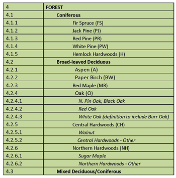
The classification scheme may change slightly as test maps are produced, depending on the ability to collect field samples as needed and the accuracy of the classes, but the current scheme comprises the final ‘wish list’ of map categories. The more detailed classes, though challenging to map, will allow Wiscland 2 to be used for a variety of natural resource management, habitat modeling, and conservation planning activities, but also require increasing the total amount of training data needed across the state.
Several agricultural classes are going to be included in the Wiscland 2 map, but instead of being classified from the satellite data, these areas are based on a crop rotation dataset that the DNR has already created. The dataset was produced by identifying typical 5-year crop rotations and classifying areas based on the annual change in crop type using several years of crop type data from the USDA Crop Data Layer. In the final product, each agricultural crop area is labeled with a general rotation type (e.g. cash grain, vegetable, etc.). Similarly, known cranberry bogs and tree farms have been previously mapped across the state. Once the Wiscland 2 classification process for the other classes is complete, these areas will be overlaid on that map and ‘burned’ in to the final product to identify these agricultural areas.
Training and Validation Samples
One of the major goals of the Wiscland 2 project has been to try to gather as many data points from existing datasets to limit the need for additional field collection. To date, 21 existing datasets from across the state have been collected, ranging from statewide forestry data to regional studies of bird and badger habitat.
After undergoing a variety of quality assurance checks, class assignments, and generating points from samples at least 2 acres in size, over 1 million sample points were harvested from these existing datasets. These points form the base of the training data used to ‘teach’ the computer to identify the various land cover types, as well as to assess the accuracy (validation) of the final maps.
While many points are available, the points are not distributed through the state or across classes evenly. As such, we worked with the DNR to develop field collection training and tools to fill in gaps in the sample database. The DNR has begun training field staff and recruiting limited-term employees (LTEs) to collect approximately 13,000 additional points starting in April and completing by September. Online and in-person DNR training began on April 21st and will continue throughout May. The DNR created a variety of training videos that DNR field staff can access on demand for initial training as well as refreshers on the needs, methods, and importance of the field collection efforts to the success of Wiscland 2.
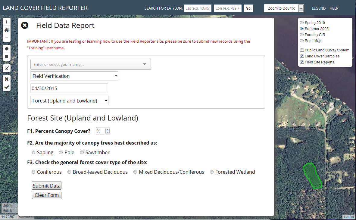
To assist the DNR in submitting these field points, we created an online “field reporter” tool that allows field staff to outline their collection area on an aerial photograph, enter metadata and characteristics of the field site, and submit that data to us for use in the making of the map. This growing dataset will allow us to move mapping beyond the broad-level categories and start refining the map to the most specific classes.
Also, manual interpretation of aerial photographs to identify training samples for developed, water, and barren land cover classes are nearly complete. Because these classes are easily identified using aerial photos, unlike many of the grassland, wetland, and forest categories desired for Wiscland 2, the project team was able to manually photo-interpret these training sites, leaving the DNR trained staff available to collect the more complex classes.
In addition to assisting the DNR field staff with monitoring the status of the field collection, our upcoming high-priority tasks include processing the over 100GB of imagery data available for each of the 13 Wisconsin Landsat footprints that are needed to create the statewide map and further refining the classification processes that will be used to create the 4 different map ‘levels’. Taking a top-down approach, classification begins with the broadest categories of land cover by creating a statewide land cover map of ‘level 1’categories that will be used as a base for the more detailed (levels 2, 3, and 4) map products. We are currently conducting cross-validation to evaluate the performance of several different models we have developed to classify our datasets. Once the methodology is validated for the test region, we will expand the classification statewide. There is a lot of work to be done, but things are progressing on schedule for the final product to be completed by June 2016.
For the latest project information, be sure to visit the Wisconsin Landcover 2 Project Page.
The Wiscland 2 project is a cooperative effort between UW-Madison and the Wisconsin DNR, with funding from the Federal Aid in Wildlife Restoration Program, grant #W‐160‐P‐25