
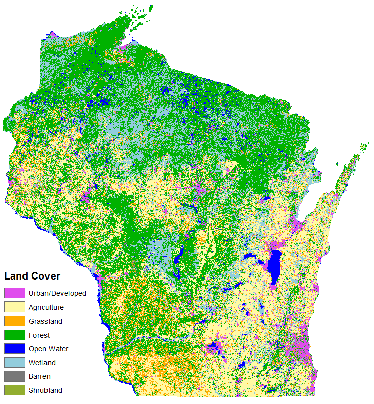
Just before the New Year, the Wiscland 2 project team completed a draft “Level 1” land cover map for the state of Wisconsin. This level of classification breaks the landscape down into eight major land cover classes –Agriculture, Urban Areas, Grasslands, Forests, Water, Wetlands, Barren Areas, and Shrubland – providing a fascinating view of the current state of land cover in Wisconsin. There is still a lot of work to be done before the final product is released later in 2016, but the initial output is looking great!
To create this product, we used over 2.5 terabytes of Landsat satellite imagery and almost 250,000 land cover samples to train a machine learning classification algorithm. Each of the 13 footprints that cover the state was individually classified before being knit together into a single statewide map.
We refined the classification results by introducing information on the natural boundaries between land cover that we derived using an image segmentation algorithm. Unlike the pixel-based classification, which classifies each pixel independently, image segmentation uses contextual information to group adjacent pixels into objects (or ‘segments’) based on the spectral similarity of their neighbors. To merge the image-based segments with the classified map, a majority rule was applied so that the class making up the majority of each segment was assigned to all pixels within that segment.
Right now, this interim product is being reviewed by program-area experts at the Wisconsin Department of Natural Resources, along with several other state and federal agencies, who will use their specialized knowledge of Wisconsin’s landscape to evaluate the quality of the map. With their input, the project team will complete the final revisions to the Level 1 map over the next month. Achieving a reliable Level 1 classification is particularly important because that map will inform the development of the higher detail Level 2-4 maps that we will be producing over the next five months.
For the latest project information, be sure to visit the Wisconsin Land Cover Project Page and our most recent quarterly report to DNR.
The Wiscland 2 project is a cooperative effort between UW-Madison and the Wisconsin DNR, with funding from the Federal Aid in Wildlife Restoration Program, grant #W‐160‐P‐25.