
Initial settlement dates on Washington Island
At the WLIA (Wisconsin Land Information Association) Fall Regional Meeting in Oshkosh last month, Will Craig, Associate Director of the Center for Urban and Regional Affairs (CURA) at the University of Minnesota, presented a study of Washington Island’s settlement history. The study details the processes used to collect and map the dates of initial land transfers on the Island. It starts by describing the PLSS (Public Land Survey System) and goes on to document the various ways that land was transferred from the public domain. Some of these transfer mechanisms are not well known, such as The Swamp Land Act, Canal Grants, and Military Warrant. These mechanisms had a significant impact on Washington Island’s settlement patterns and on the state as a whole.
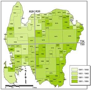
Initial European settlement of Washington Island, located on the northern edge of Door County, was associated with the fishing industry in the 1840s. Later settlement was associated with the expansion of forestry and agriculture on the Island. The last areas to transfer to private ownership were on the east coast, an area valued today for scenic views over Lake Michigan.
The study documents the methods used to collect information on initial land transfers, including records at the BLM (Bureau of Land Management), BCPL (Board of Commissioners of Public Lands), and county Register of Deeds offices. The methods used to map the data using GIS technology are also documented.
Will Craig is widely regarded as one of the pioneers of urban and regional information systems and GIS. In his 40+ year career his initiatives have included data sharing, multipurpose cadastral data, spatial data infrastructure, public participation GIS, and ethics. He has held several key positions in professional GIS societies including President of URISA (Urban and Regional Information Systems Association), 1986-87; President of the UCGIS (University Consortium for Geographic Information Science), 1997; and President of NSGIC (National States Geographic Information Council), 2009-10. Craig’s interest in Washington Island’s history stems from the fact that he owns land there, as documented in the study.
Craig’s co-authors are Randy Bixby (Wisconsin Board of Commissioners of Public Land), Mark B. Lindberg (University of Minnesota), and Tom Haight (Door County Land Information Office).
A PDF of the study can be downloaded here from the SCO publications page.
Interested readers are encouraged to contact Will Craig directly with comments and questions.