
The Wisconsin Coordinate Reference Systems (WISCRS) primarily used by cities and counties in the state are now included in the International Association of Oil & Gas Producers (IOGP) Geodetic Parameter Dataset. The SCO initiated a “change request” process in early August, which resulted in the parameters being added for the November 25, 2015 release of the parameters database. The IOGP database is the de facto international registry for coordinate system parameters.
Software developers and open source software users are the main beneficiaries of this action. Having an EPSG code simplifies projection operations considerably for users not familiar with the nuances of geodesy. (EPSG is a legacy name for the IOGP, which was retained for historic purposes.)
For example, projecting a raster from WISCRS Dane County to Wisconsin Transverse Mercator in GDAL goes from:
gdalwarp -s_srs "+proj=lcc +lat_1=43.0695160375 +lat_0=43.0695160375 +lon_0=-89.42222222220001 +k_0=1.0000384786 +x_0=247193.2944 +y_0=146591.9896 +ellps=GRS80 +units=us-ft +no_defs" -t_srs EPSG:3071 dane_wiscrs.tif dane_wtm.tif
To the much simpler:
gdalwarp -s_srs EPSG:7493 -t_srs EPSG:3071 dane_wiscrs.tif dane_wtm.tif
Similarly, software developers can easily consume parameters from the internationally-recognized Geodetic Parameter Dataset and implement WISCRS in a standardized way, without any manual data entry.
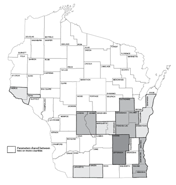 Shared WISCRS parameters. (click to enlarge)
Process was not without controversy
To my own surprise, we did experience some “bumps” in the process. Technically, WISCRS is comprised of 59 different sets of coordinate parameters. A number of counties, because of their geographic proximity, share coordinate parameters (e.g., Adams/Juneau, Green/Lafayette.)
However, as a matter of policy, the SCO has always published 72 different sets of parameters, and users in our state commonly refer to “WISCRS – Adams County” and “WISCRS – Juneau County” as unique systems. Therefore, our request to IOGP was to register all 72 counties as unique systems.
However, in short, the IOGP refused to recognize WISCRS as 72 unique systems. They felt registering 59 unique systems was more in line with their past practices and policies.
The implication: some counties will share an EPSG code. In the Adams/Juneau example, they both will be referenced with a single EPSG code of 7528 (meters) or 7587 (US Survey Foot).
Does this matter from a technical perspective? Not at all. In my opinion this is more of an inconvenience than anything else, which we will have to overcome with education.
Next steps
In the coming months, we expect to update our Wisconsin Coordinate Reference Systems handbook to include the EPSG codes. We also plan to publish some best practices for implementing WISCRS.
If you have any questions about the new EPSG codes, or WISCRS in general, feel free to contact me at (608) 262-6850.