
Download Wisconsin Elevation Data
While Wisconsin does not have a statewide LiDAR dataset available, visit the WisconsinView Data Portal for the state’s best archive of public domain LiDAR-derived elevation data.
For raw point cloud data, requesters must contact the Land Information Office in the county of interest.
Visit the Wisconsin DNR FTP site for a statewide 10-meter resolution elevation dataset developed by the U.S. Geological Survey from a variety of data sources.
The State Cartographer’s Office (SCO) and Wisconsin Department of Natural Resources (DNR) frequently receive requests for information on Wisconsin digital elevation data, particularly high-resolution LiDAR.
The map below shows all county LiDAR data known to exist by the Wisconsin DNR. Like all status maps, it is subject to change and will be revised periodically.
Specifically, this map shows counties for which DNR has produced standard, 5-foot resolution, hydro-flattened, bare-earth county-based DEMs from county-acquired LiDAR data. In addition, a few counties (e.g., Brown, Ozaukee, Dane) have also made 5-foot DEM data available via WisconsinView. Acquisition of this LiDAR data was funded with U.S. Department of Housing and Urban Development’s “Community Development Block Grant Program” coordinated through DNR. County-based 5-foot DEM datasets are available free of charge via the WisconsinView Data Portal (first time use requires basic registration). The DEMs are in ArcGIS GRID format, referenced to the county-based Wisconsin Coordinate Reference System (WISCRS) or State Plane Coordinates (SPC), Wisconsin South Zone.
The map also shows counties in which other LiDAR-related data, such as LAS point clouds and breaklines, are not currently available from WisconsinView. Please contact the specific county Land Information Office to determine the types, availability, and extents of these LiDAR datasets.
For questions on the LiDAR inventory map, contact the DNR Bureau of Technology Services. All LiDAR-derived DEMs produced by DNR are available for free from the WisconsinView Data Portal.
Note: the inventory map was updated on 10/5/2016.
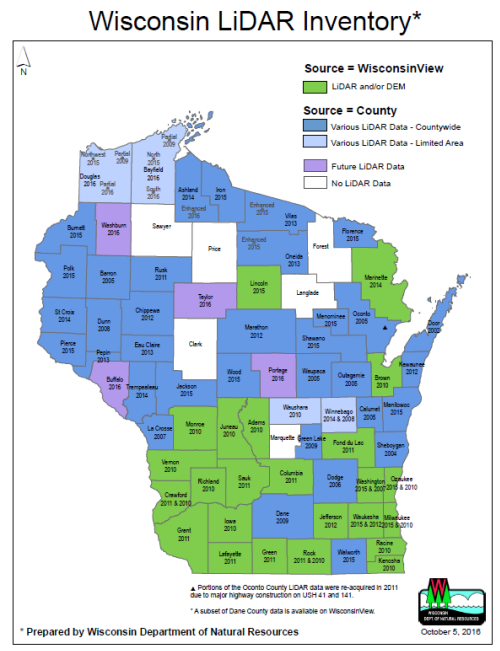
Wisconsin LiDAR status as of October 5, 2016.
Click for a larger map.