
Note: Mick Heberlein at the WisDOT Office of Surveying & Mapping provided most of the content for this article, including text and tables. Maps are screenshots from the NGS’s GPS on Bench Marks dashboard apps.
The National Geodetic Survey (NGS) developed the GPS on Bench Marks (GPS on BM) campaign to help prepare for National Spatial Reference System (NSRS) modernization. Under this campaign, NGS is asking state and local surveyors to collect GPS observations on a series of priority monuments distributed across the country. GPS on BM will improve conversions from current horizontal and vertical datums to the North American Terrestrial Reference Frame of 2022 (NATRF2022) and North American-Pacific Geopotential Datum of 2022 (NAPGD2022) respectively.
In Wisconsin the GPS on BM campaign is being coordinated by the Wisconsin DOT (WisDOT) under the “GNSS Observation on Passive Stations Project.” Many non-DOT partners are involved in the project.
You can read more about the rationale and background on GPS on BM in this SCO news article, published earlier this year. That article also gives a status report on the initiative in Wisconsin as of June, 2021. Below you will find an update to that status report, using statistics from early September, 2021. The state has made great progress over the summer. With four months to go on the initiative, there’s still time to reach all of the project goals.
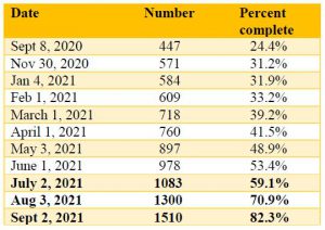
Status of Wisconsin’s 10-km hexagons
NGS has divided the entire nation into a series of 10-km hexagons, with the goal of getting at least one observation per hexagon. There are 1833 hexagons in Wisconsin. Hexagons are completed as a result of either an OPUS (NGS’s Online Positioning User Service) shared station observation or a station submitted to NGS via Bluebooking within the hexagon.
Table 1 shows activity since September, 2020. The last three rows of the table, highlighted in bold, show progress since the June, 2021, status report. The September 2021 figure of 1510 hexagons represents an increase of over 50% since June.
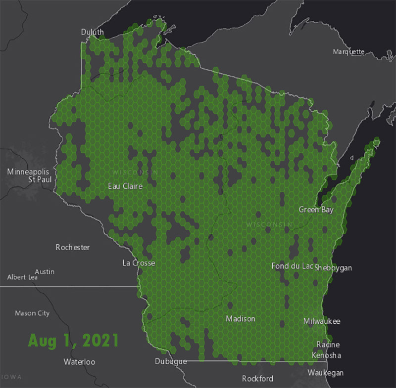
Map 1 shows the status of Wisconsin’s 10-km hexagons.
The NGS progress dashboard can be found here.
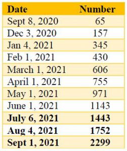
Wisconsin’s OPUS solutions
In terms of the number of observations appearing on the NGS OPUS Dashboard, Wisconsin’s total has more than doubled since June (see Table 2).
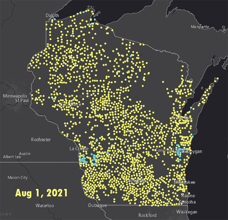
Map 2 shows the status of Wisconsin’s OPUS solutions.
The NGS progress dashboard for OPUS solutions can be found here.
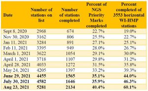
Priority list status
NGS has produced a prioritized list of bench marks where additional GPS data is needed. The stations on the priority list are chosen by an NGS algorithm based on station location and metadata without regard to its status as a WI-HMP station. NGS adds additional stations to the priority list after certain stations are observed.
Table 3 shows the number of priority stations completed over time in Wisconsin. The last three rows of the table, highlighted in bold, show progress since the June, 2021, status report.
HARN stations
One goal of the WisDOT’s GNSS Observation on Passive Stations Project is to get two observations on all original HARN stations or their replacements in Wisconsin. There are 80 stations in total. The original HARN stations are a higher accuracy station and provided the initial control from which all other horizontal stations in Wisconsin were surveyed from. As of September 2, 2021, 74 of the 80 HARN stations have been completed. (Table 4)
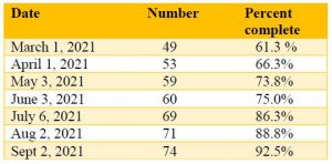
Remaining stations include one in each of Fond du Lac, Vilas, Oneida, Sheboygan and Washington counties. The remaining station in Milwaukee county has been destroyed.
Your role
You can help improve the National Spatial Reference System (NSRS) and prepare for the NSRS modernization by participating in GPS on BM campaign. Your efforts will support improving the transformation tool to enable conversions to the new 2022 datums, help maintain the passive control network, and ensure new coordinates are calculated for all observed marks. Details about how to get involved are on the NGS GPS on BM website.
For those of you who don’t have GPS equipment but still want to contribute, consider recovering NGS marks and reporting the station condition to confirm whether the station is suitable for satellite observations using the NGS Mark Recovery Form.
It’s important to emphasize that the GPS on BM deadline of December 31, 2021, is less than four months away.
For more information you can also contact Mick Heberlein at the WisDOT or Jacob Heck with NGS.