
Note: Mick Heberlein at the WisDOT Office of Surveying & Mapping provided most of the content for this article, including text and tables. Maps are screenshots from the NGS’s GPS on Bench Marks dashboard apps.
The National Geodetic Survey (NGS) developed the GPS on Bench Marks (GPS on BM) campaign to help prepare for National Spatial Reference System (NSRS) modernization. Under this campaign, NGS is asking state and local surveyors to collect GPS observations on a series of priority monuments distributed across the country. GPS on BM will improve conversions from current horizontal and vertical datums to the North American Terrestrial Reference Frame of 2022 (NATRF2022) and North American-Pacific Geopotential Datum of 2022 (NAPGD2022) respectively.
According to Jacob Heck, NGS’s Great Lakes Regional Geodetic Advisor, the primary role of GPS on BM is to improve results for the vertical datum. The initial goal of the campaign was to collect data to go into the transformation tools that will be used to tie NAVD 88 to NAPGD2022. Thus the priority list is composed of vertical marks. On the horizontal side, the transformation between NAD 83 and NATRF2022 is more straightforward, so this type of high-density survey isn’t really necessary to build that transformation.
You can read Jacob’s in-depth article about GPS on BM here in the Winter 2021 edition of Hoosier Surveyor.
That said, data from horizontal-only marks are still useful to connect data to the new horizontal reference frame, NATRF2022. An additional benefit of participating in GPS on BM is that observed monuments will be automatically reprocessed and given new coordinates after NSRS modernization occurs. This will ensure higher coordinate accuracy and preserve past investments in the passive control network. Stations not observed and processed by December 31, 2021 will have new coordinates that are transformed rather than calculated.
A flyer highlighting the GPS on BM program for Wisconsin can be found here.
The NGS’s GPS on BM website is here.
In Wisconsin the GPS on BM campaign is being coordinated by the Wisconsin DOT (WisDOT) under the “GNSS Observation on Passive Stations Project.” Other non-DOT partners are involved in this project. A partial list includes: J.W. Austin Associates of Minocqua, Vernon County, LaCrosse County, Dodge County, Dunn County, Brown County, Sheboygan County, Washington County, Burnett County, Manitowoc County, Jackson County, Clark County, Sawyer County, Washington County, City of Madison, Landtech Surveying of Oconomowoc, Seiler Instruments, Leica Geosystems, Milwaukee Metropolitan Sewerage District, and Northeast Wisconsin Technical College.
Status of Wisconsin’s 10-km hexagons
NGS has divided the entire nation into a series of 10-km hexagons, with the goal of getting at least one observation per hexagon. There are 1833 hexagons in Wisconsin. Wisconsin is now second in the nation with a total of 978 hexagons completed. Minnesota has 2649 completed, Illinois has 977 and North Carolina has 731.
Hexagons are completed as a result of either an OPUS (NGS’s Online Positioning User Service) shared station observation or a station submitted to NGS via Bluebooking within the hexagon.
Since September, 2020, Wisconsin has completed an average of almost sixty hexagons per month (see Table 1).
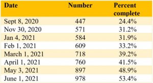
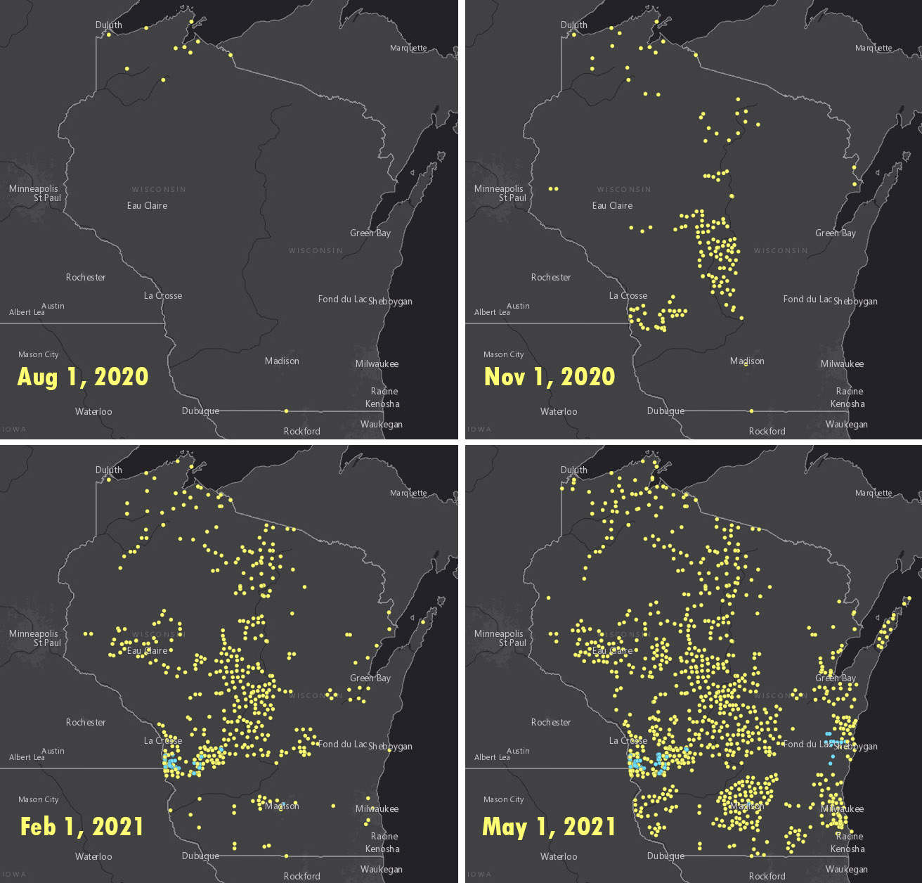
Map series 1 shows the progress over time completing Wisconsin’s 10-km hexagons.

The NGS progress dashboard (showing Wisconsin’s progress as well as the country as a whole) can be found here.
Wisconsin’s OPUS solutions
In terms of the number of observations appearing on the NGS OPUS Dashboard, Wisconsin has been adding over 100 per month on average (see Table 2).
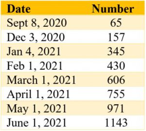
This table includes all observations by WisDOT and partners, and includes Wisconsin Height Modernization Program (WI-HMP) stations as well as non-WI-HMP stations. In WI-HMP there are approximately 5,288 vertical-only stations and 3,553 stations with a horizontal component for a total of 8841 stations.
Map series 2 shows the progress over time for Wisconsin OPUS solutions.
The NGS progress dashboard for OPUS solutions can be found here.
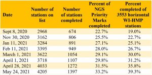
Priority list status
NGS has produced a prioritized list of bench marks where additional GPS data is needed. Providing GPS on stations with leveled elevations will help to relate the GPS derived ellipsoid height with the leveled elevation of these marks. The stations on the priority list are chosen by an NGS algorithm based on station location and metadata without regard to its status as a WI-HMP station. NGS adds additional stations to the priority list after certain stations are observed.
Currently, there are about 15,000 NGS benchmarks in Wisconsin (both WI-HMP and non-WI-HMP). Most non-WI-HMP stations have relatively little current survey value, but may have important older surveys tied to them. Not all WI-HMP stations are currently on the priority list. The vast majority of observations are on WI-HMP horizontal stations.
WisDOT has created a GIS map showing all Wisconsin Height Modernization stations with the NGS hexagons, completion status and number of OPUS shared observations. That map is available here. WisDOT has performed many additional observations that do not yet appear on the NGS OPUS map or GPS on BM priority list.
Table 3 shows the number of priority stations completed over time in Wisconsin.
HARN stations
One goal of the WisDOT’s GNSS Observation on Passive Stations Project is to get two observations on all original HARN stations or their replacements in Wisconsin. There are 80 stations in total. The original HARN stations are a higher accuracy station and provided the initial control from which all other horizontal stations in Wisconsin were surveyed from. As of June 3, 2021, 60 of the 80 HARN stations have been completed.
Your role
You can help improve the National Spatial Reference System (NSRS) and prepare for the NSRS modernization by participating in GPS on BM campaign. Your efforts will support improving the transformation tool to enable conversions to the new 2022 datums, help maintain the passive control network, and ensure new coordinates are calculated for all observed marks. Details about how to get involved are on the NGS GPS on BM website.
For those of you who don’t have GPS equipment but still want to contribute, consider recovering NGS marks and reporting the station condition to confirm whether the station is suitable for satellite observations using the NGS Mark Recovery Form.
For more information you can also contact Mick Heberlein at the WisDOT or Jacob Heck with NGS.