
Over 100 people gathered together for the 2024 Geospatial Summit on April 10th. The event was the first occurrence since the pandemic forced organizers to pause the annual in-person activity for several years. The Geospatial Summit offers an opportunity to share geospatial research and program updates, employment and internship opportunities, and new ideas and initiatives.
Summit attendees included students, staff and faculty at UW–Madison and other Universities of Wisconsin campuses, staff from government agencies at all levels, representatives from the private sector and non-profits, and the general public. The event is always free and open to all.
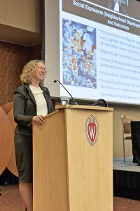
This year’s keynote featured Dr. Amy Kind, Associate Dean for Social Health Sciences and Programs; Executive Director, Wisconsin Partnership Program; Director, UW Center for Health Disparities Research (CHDR); and Professor, Department of Medicine, Division of Geriatrics, in the University of Wisconsin School of Medicine and Public Health. Dr. Kind spoke to a very engaged audience on “Advancing Precision Medicine via Social Exposome Geography”. Her talk helped people understand the concept of the “exposome” encompassing the totality of environmental (non-genetic) exposures through a person’s life, and its effects on health. Dr. Kind theorizes that biological, behavioral, sociocultural, and economic mechanisms – even structural inequities such as systemic racism – may be a modifiable factor influencing health risk and resilience.
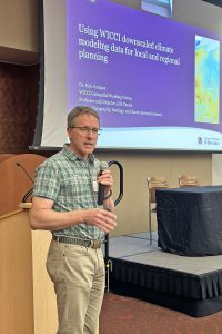
Following the keynote address, three speakers gave presentations on a variety of new and innovative geospatial projects in Wisconsin. Dr. Eric Compas, Professor in the UW-Whitewater Department of Geography, talked about a new series of downscaled climate geospatial datasets now available for downloading and analysis from GeoData@Wisconsin, an online geoportal featuring datasets for Wisconsin. Dr. Compas described how the geospatial formats from the complex climate model data were generated, and gave some visual examples on the kinds of analysis and visualizations that can be done.
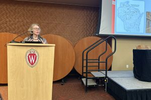
Dr. Sue Swanson, the Wisconsin State Geologist and Director of the Wisconsin Geological and Natural History Survey (WGNHS), provided an overview of some geospatial and mapping projects at the survey, including a new Quaternary Geologic map of Wisconsin due to be published by the end of this year. Dr. Swanson highlighted innovative mapping technologies that are being introduced into county geologic mapping processes and described how users can locate and download online data and maps from the WGNHS.
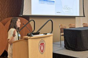
Finally, Danielle Tanzer, UW-Madison’s geospatial data coordinator at the Arboretum, presented the different ways GIS technology and geospatial data are used to assist in managing and maintaining Arboretum lands. Of particular note were a series of historical maps showing where vegetation and features have existed on the landscape through time. These maps are being digitized to offer an entirely new way of analyzing Arboretum lands, both past and present.
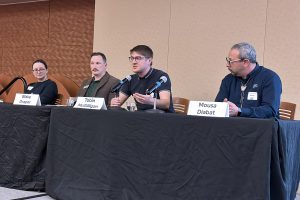
The afternoon session featured a career panel aimed at informing and engaging attendees in the career search process, mentorship in the field, skill building and retention, and diversity, equity, and inclusion in the workplace. The panel featured Blake Draper (Supervisory Geographer and WIM Development Team Lead, US Geological Survey Middleton – Web Informatics and Mapping), Tobin McGilligan (Project Manager, CARTO, and a UW-Madison alum), Caroline Rose (Cartographer & GIS Specialist, Wisconsin Geological and Natural History Survey, also a UW-Madison alum), and Mousa Diabat (Technical Expert in Hydrology and Thermography, NV5).
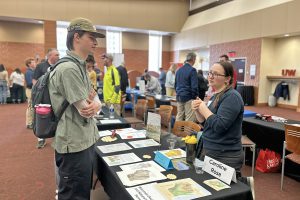
The day wrapped up with a successful career fair where attendees visited with professionals from Ayres Associates; CARTO; Esri; NV5; Resource Environmental Solutions (RES); Seiler Instrument; USGS Web Informatics and Mapping; UW-Madison Graduate Geospatial Programs; UW-Madison Physical Plant; Wisconsin Geological and Natural History Survey; Wisconsin State Geospatial Information Committee (SAGIC); Mandli Communications; Cloudpoint Geospatial; Landscan; Mead & Hunt; and Silvernail Studio for Geodesign.
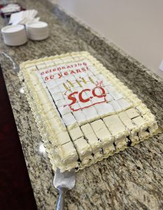
Another highlight was the cake in honor of the State Cartographer’s Office 50th anniversary!
The 2024 Geospatial Summit was planned jointly by staff from the UW–Madison Geography Department, the Nelson Institute, the Department of Planning and Landscape Architecture, the GIS Professional Programs, the Cartography Lab, the Robinson Map Library, and the State Cartographer’s Office. Funding for the event was provided by the Robinson Map Library and the State Cartographer’s Office.
If you attended, please take a moment to fill out our survey to help improve the event next year.