
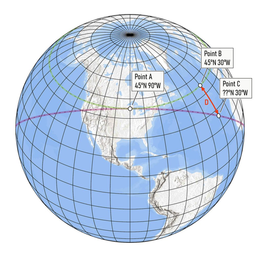
A few years ago, I did a blog post challenging readers to compute the deviation along a meridian between a given parallel and a great circle arc tangent to that parallel at a point. This is shown by the arc labeled D in the diagram. While a parallel (line of latitude) bears the same angular relationship to every meridian – running due east and west – the great circle arc is the path you would follow if you used a compass to travel east or west of the point of tangency.
Paradoxically, due east (or west) has two different meanings.
The problem has practical implications, accounting in part for the wobbles in Public Land Survey System (PLSS) boundaries. When the PLSS was created, surveyors often needed to survey a parallel of latitude (the Illinois-Wisconsin boundary is an example) in less-than-ideal conditions. The so-called “tangent method” to determine a true latitude line (i.e., a parallel) is based on the projection of the easterly line from the initial point of tangency. A correction factor is then used to shift locations from the resulting great circle arc back to the parallel.
My solution to the problem, posted here, is based on solving spherical triangles using trigonometric rules that have analogs in Euclidean geometry. The key to solving the problem is to define a set of spherical triangles for which we know at least three of the six angles and sides. With those three pieces of information, the unknown angles and sides can be computed.
I also posted a solution by Dr. Louis Strous, whose approach involves converting latitude and longitude to 3-dimensional Cartesian coordinates (x, y, z) and then computing the location of a point at a known distance from a starting point traveling in a known direction.
A few months ago, I was contacted by Dr. William C. Rose, Associate Professor Emeritus, College of Health Sciences, University of Delaware, who offered another solution. Dr. Rose has a BA in Physics from Harvard and a PhD in Biomedical Engineering from Johns Hopkins. At the University of Delaware, he taught anatomy, physiology and biomechanics. But Rose also has an interest in geodesy and a background in trigonometry that I sorely lack. (I avoided math until grad school.)
Rose offers another solution to the reader challenge, using spherical trigonometry and Taylor series for the quadratic approximation. As he explains,
Since the 1973 Manual [of Surveying Instructions for PLSS] gives a quadratic approximation formula (i.e., a formula that says the offset is proportional to the square of the longitudinal distance from the initial point), I did the Taylor series approximations to obtain an analogous quadratic approximation formula. The 1973 manual uses Δm for the horizontal distance, in chains. I use Δλ for the horizontal distance, in radians.
Rose’s solution is here.
The three solutions presented – Rose’s, Strous’ and mine – yield the same results. As Rose notes,
Your answer is the same as my exact solution. In particular, your formula for arc Q (the colatitude of point C) is analogous to my exact solution. The quantity you call arc Q is called 90-φ+Δφ in my solution. The quantity you call arc D, I call Δφ. My equations 3 and 9 give a solution in terms of linear distance, since this is the form given in the 1973 Manual of Surveying Instructions, which you included in the challenge. But before those equations I give equations the give the answer in terms of angle, like you do.
Rose also notes, regarding the solution by Strous, that,
The x, y, z approach is interesting, because it uses cross products and dot products of vectors. It is well-known that one can reproduce all the formulas of spherical trigonometry by this approach.
So now you have three different ways to solve this problem, should you ever need them. But it’s also an important lesson helping us understand what early surveyors had to go through and why some of our PLSS boundaries – and some state boundaries – don’t necessarily follow their intended course. Additionally, those cartographers who like to embellish their maps with compass roses should take heed. Are those compass lines saying what you think they do?
Finally, Dr. Rose also offered this bit of geodetic trivia as a byproduct of his solution.
Your reader challenge explains an interesting phenomenon: on the equinoxes, viewers all over the world see sunrise due east, no matter what their latitude. It seems a bit surprising that observers from one pole to the other will all see sunrise in the exact same direction. After all, the direction of sunrise is not the same for all observers on other days of the year. On the equinox, the Sun’s geographic position (GP, point on the earth where the sun is exactly overhead) is on the equator. One can show with mathematics or by thinking enough about geometry, that if you follow the great circle in your challenge problem for an arc of 90 degrees, you will exactly reach the equator, no matter what your latitude. And when the arc from the observer to the sun’s GP is 90 degrees, then the sun is on the horizon. Thus, on the equinox, observers at all latitudes see the sunrise exactly east.
Remember this – it will probably come in handy at your next King Trivia game!
And a reminder that the vernal equinox occurs on March 20th this year. When you see the sun rise on that day, you will looking due east.