
I had the opportunity to travel to Denver, Colorado on May 12th and 13th to attend the first-ever National Map Users Conference. To sum it up in a few words, I have to say I was extremely impressed with the show put on by the U.S. Geological Survey (USGS) for the 400+ conference attendees.
The goal of the conference was to “serve and enhance communications among the communities of users of The National Map, Federal GIS specialists and scientists, and data providers.” Highlights included a plenary session each morning, followed by a series of six or more concurrent breakout session covering themes such as partnerships, elevation data, orthoimagery, the National Hydrography Dataset (NHD), and more. A “doctor’s office” was also offered to attendees who wanted to see National Map products in action.
Mark DeMulder, Director of the USGS National Geospatial Program, gave what I felt was very useful and eye-opening overview of The National Map on Thursday morning. Although I’ve been aware of The National Map for several years now, I have to admit I didn’t often think of “it” as much more than an interactive map viewer backed up by a data gathering effort in cooperation with state and local governments.
Mark explained The National Map is best conceptualized as a suite of products and services, versus a single online viewer. This includes, for example, streaming data services (elevation, geographic names, hydrography, imagery, and more), visualization tools, online downloadable maps (US Topo, The National Atlas), and scanned/georeferenced historic topographic quads. Putting it into my own words, The National Map is better thought of as a “brand” that wraps up many different products into one conceptual package.
Mark went on to give some interesting statistics. Over the 8+ year history of The National Map, users have downloaded over 400 terabytes of data through the National Map. Since 2009, USGS has published 40,000 (of 55,000 total) updated topographic maps as part of their US Topo product line. Users have downloaded 420,000 digital topographic maps since they became available online.
Mark also described the USGS effort to scan and georeference 250,000 historic quadrangle maps. Interestingly, the quad scanning project has some significant Wisconsin ties. Greg Allord, Product Manager for historic quadrangle maps, leads the topo scanning project from his Madison office. The Robinson Map library at UW-Madison, with support from Greg, is a key partner in scanning a large number of historic quads held in their archives. Dr. James Burt, Jeremy White, and Dr. A-Xing Zhu, all with the Geography Department at UW-Madison, developed a software packed called “QUAD-G” that is used by USGS to automatically georeference scanned quads. By one estimate, the UW-developed software will save the USGS approximately $3 million in labor costs over the course of the scanning project.
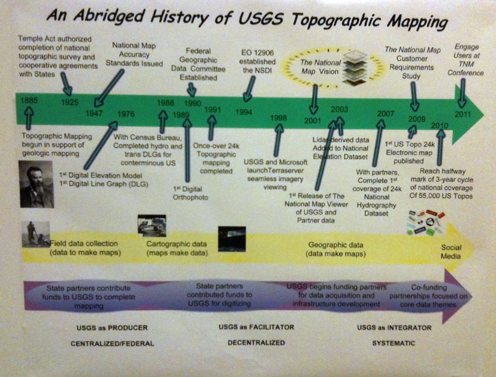
Poster displayed in the hallway during the National Map Users
Conference. Note reference to USGS as an integrator of data.
I was particularly interested in a poster I found that describes the long history of topographic mapping in the United States. What’s noteworthy on the poster, I think, is how USGS now considers itself an “integrator” of data. This represents a major paradigm shift from the early years of topo mapping, and further highlights the reality that the largest scale (greatest detail) data are produced by state and local governments.
Jay Parrish with the state of Pennsylvania gave a very interesting talk on the motivations behind partnerships. Jay spoke to several common “motivators” for partnerships including loyalty, greed, desire, pragmatism, altruism, and politics. Of these, Jay suggested that altruism plays a greater role than one might think in developing and maintaining partnerships. I look forward to reviewing his presentation once it becomes available on the Conference Web site.
I was invited to speak on the 2010 Wisconsin Regional Orthophotography Consortium (WROC), and what it took to pull together that effort over the last several years. I described the history that ultimately led to the creation of WROC, the benefits of the project, and also some of the challenges encountered. Interestingly, several folks in the audience thought WROC would be a great model for their own states. It’s great to hear that Wisconsin could once again be a leader and a model for other statewide geospatial programs.
During a closing plenary session, Mark DeMulder and Vicki Lukas, Chief of National Geospatial Program Partnerships, gave a summary of National Map feedback they heard during the conference. Comments generally fell into areas such as awareness, visibility, access (to data and information), and a need to focus on priorities. On the subject of access, they acknowledged the rapidly-growing mobile industry, and a need for USGS to move more quickly into that arena. During the discussion on priorities, it became clear that USGS feels strongly about “returning to their roots” (my words) of topographic mapping. One frequent comment noted by Vicki and Mark was the “depth of data available” through The National Map. My own take on this is that USGS would be best-served by tapping into niche markets that reach traditional geospatial users and the scientific community, while leaving the “mass markets” (general public) to the likes of Google and Microsoft.
The USGS tentatively plans to hold another National Map Users Conference in two years, at a location to be determined. I thought the conference was a great outreach strategy on the part of USGS, and I hope they continue making improvements in educating the geospatial community on the role and benefits of The National Map. I definitely walked away with a much more positive understanding of the suite of products and services USGS calls “The National Map.”